Hey educators! Since the 2020 NSTA conference in Boston was cancelled over COVID-19 concerns, NESTA (National Earth Science Teachers Association) is offering educators the chance to participate in a FREE virtual conference with NESTA-sponsored presenters (including the MOSAiC team!) on Saturday, April 4, 2020 from 3 PM to 7:30 PM Eastern Time. Don't miss out on this chance to connect with other educators! Register by April 1, 2020 to hold your spot. Sneak peak: The MOSAiC team will be unveiling some brand new MOSAiC and Arctic-related curriculum. Don't miss it!
Register for the FREE NESTA virtual conference for educators on April 4th
Parents, teachers, and anyone looking for virtual, remote, and at-home learning resources: We'll be continuously updating a list of polar and MOSAiC-related remote learning resources, including videos and other multimedia, activities, online interactives and live events, and more that you can access for free. Check out the website below!
Browse our list of polar and MOSAiC-related virtual, remote, and at-home learning resources
MOSAiC Science Focus Area: The Ocean, Part I
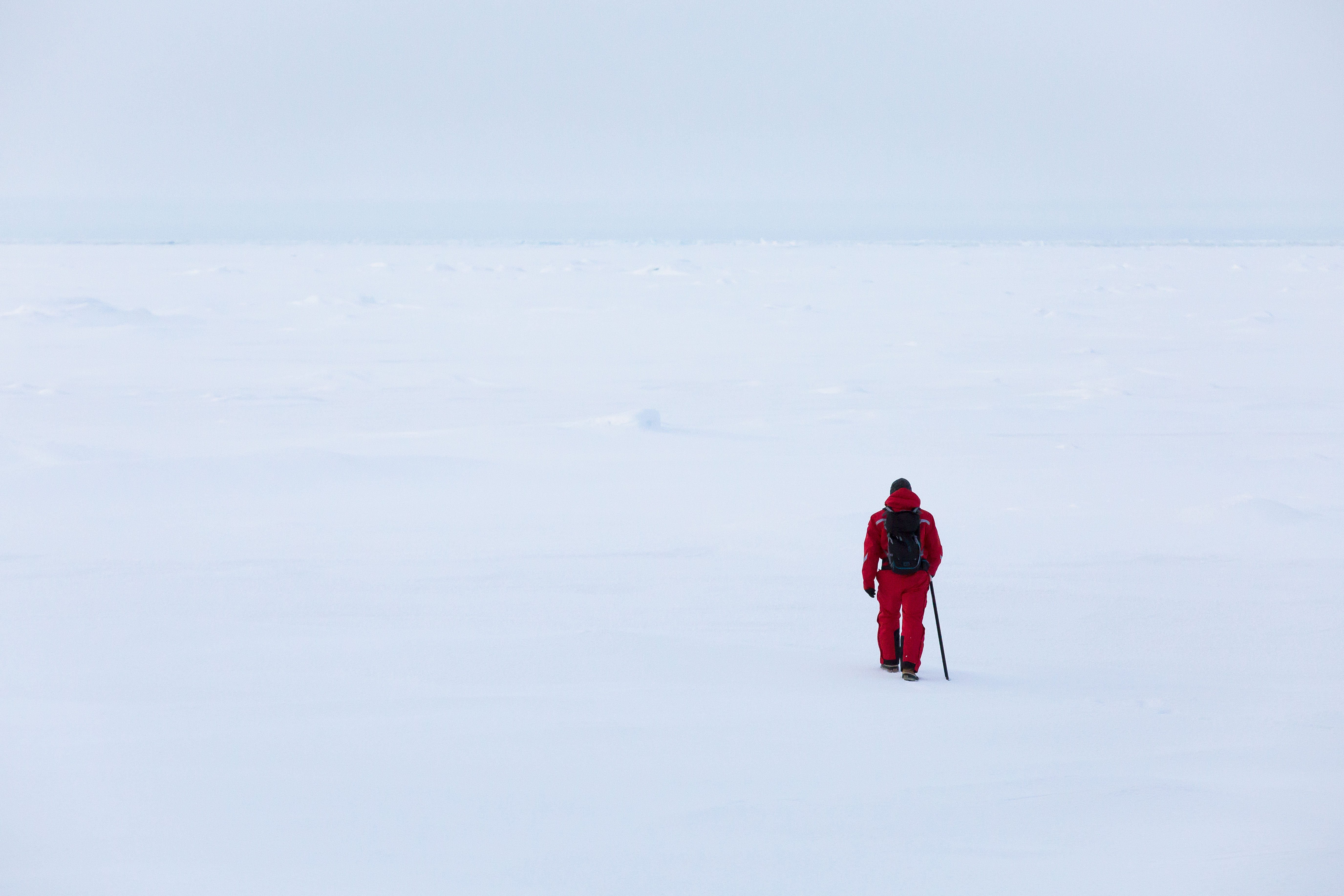
"...sometimes you can forget where you are. That moment I realized I was walking on ice that was floating on the ocean, and really feeling that, was probably one of those stand-out moments for me."
-Amy Richman, filmmaker and videographer for MOSAiC, when asked to recount some of her favorite memories from her experience on Leg I of the expedition.
Looking at this photo, it's easy to forget that beneath that thin veneer of sea ice there is a vast ocean world. Over the next few weeks, we'll dive in to the Arctic Ocean to learn more about this cold, dark, and mysterious place and why MOSAiC scientists are studying it. Photo credit: Sebastian Grote
Learn more about this MOSAiC science focus area and meet Team Ocean
A Blue Planet
If you were to look at a map or a globe, you would notice that all of Earth's oceans are connected - in fact, it's perhaps most accurate to say that Earth has one big global ocean that covers over 70% of Earth's surface, but for ease of talking about things geographically and other reasons, we tend to split up this global ocean into five smaller regional oceans: the Pacific, Atlantic, Indian, Southern, and Arctic Oceans.
The Arctic Ocean
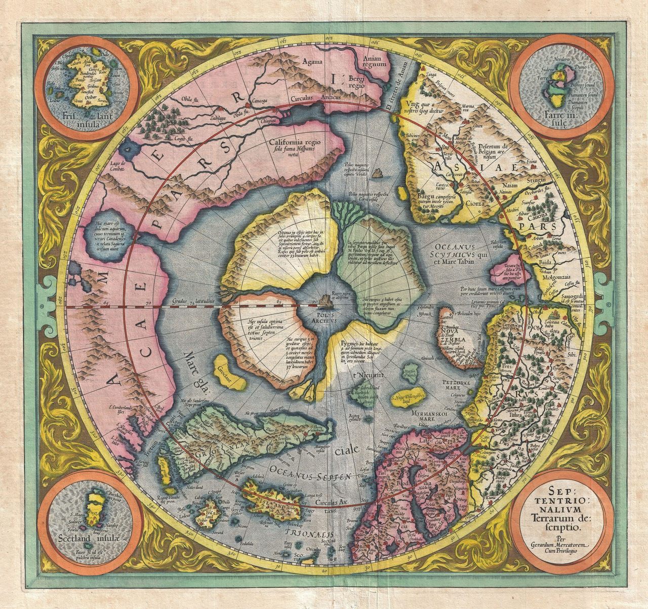
Did you know that as late as the mid to late-1800s, people still didn't know exactly what lay at the North Pole? There were all sorts of wild theories - some believed that a warm current flowed up from Japan through a thin ring of ice surrounding the Arctic and in to a vast open sea at the pole. Some thought land lay underneath the Arctic ice. Several attempts were made by expeditions in ships to try to unravel the mystery, only to be either crushed or detoured by the unforgiving Arctic sea ice. This is indeed the tragic story of the USS Jeannette, which was crushed by ice and sank in 1881 during an attempt to reach the North Pole, although the voyage of the Jeannette did lay to rest the Open Polar Sea theory. And it was sounding data from Fridtjof Nansen's 1893-1896 Fram expedition that showed that beneath the Arctic sea ice is not land, but rather a vast ocean. Image (R): 1606 Map of the Arctic by Gerardus Mercator, which features a giant magnetic mountain at the North Pole.
Explore the Arctic aboard the Fram in this 360-degree virtual Google Expedition
We now know that the Arctic is an ocean surrounded by land - an ocean that is covered by sea ice to some extent all the time (although that is changing as Earth's climate warms). The Arctic Ocean is the smallest and shallowest of the world's five major oceans, as we've defined them. But it plays an incredibly important role in Earth's climate system and supports a rich ecosystem of life adapted to extreme conditions, which we'll get into more over the next couple of weeks.
Learn all about the Arctic Ocean in this GIS exploration from Esri Canada K-12 Education
 Quick Bite: The Arctic vs. the World
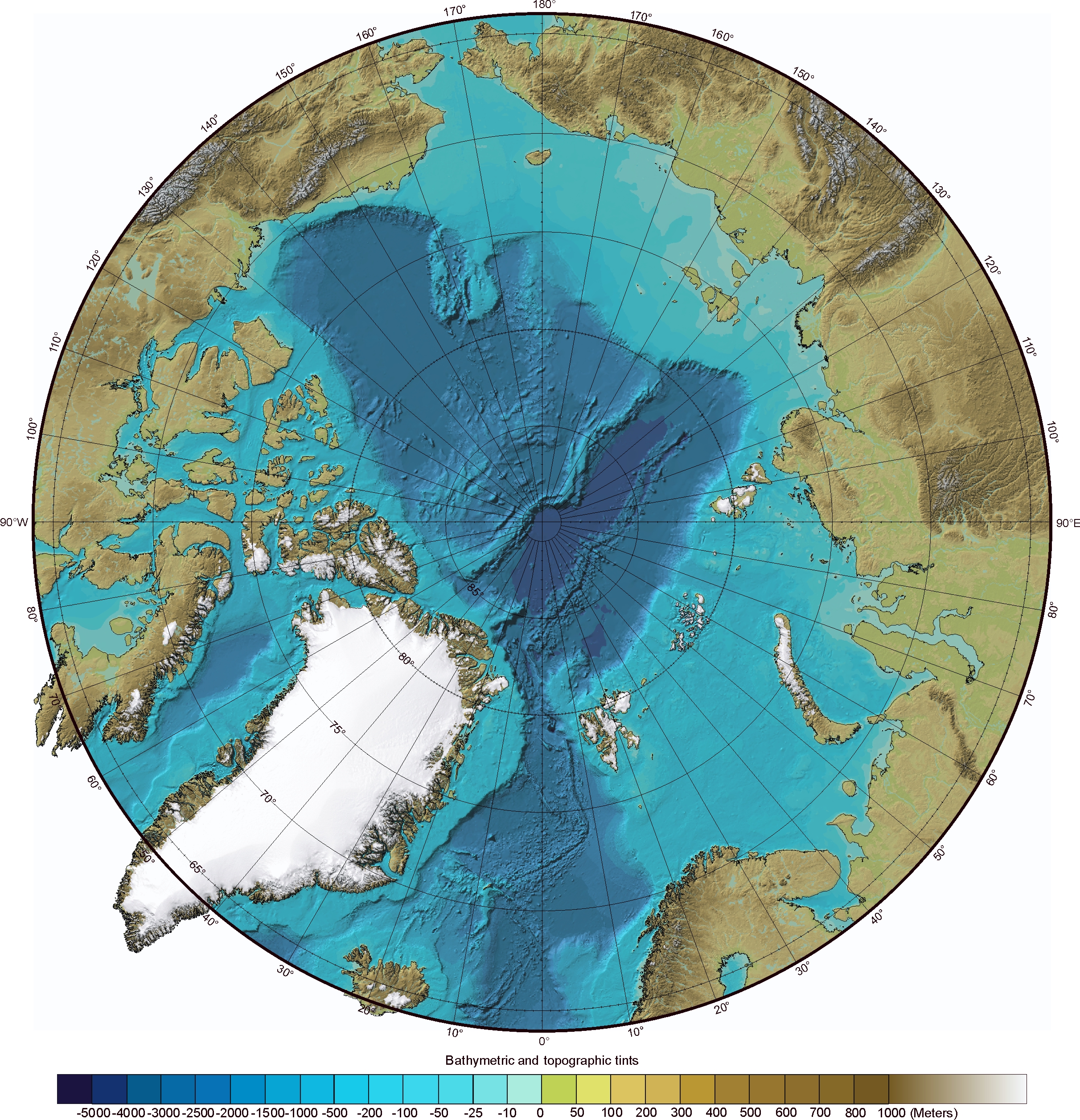
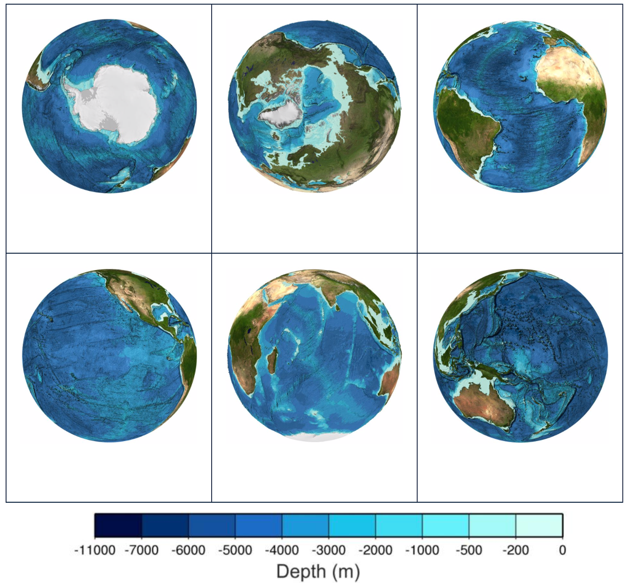
There are many things about the Arctic Ocean that make it unique. Take a look at the bathymetric map of the Arctic to the right (credit: IBCAO) (click on it for a larger view). Bathymetry is to the oceans what topography is to land - it is how deep the sea floor is. What do you notice about the Arctic Ocean and its bathymetry? Now look at the bathymetric maps of Earth's other ocean basins below (credit: GEBCO) (click on the image for access to larger versions of each). How does the Arctic Ocean compare to other oceans?
Link to large version of Arctic bathymetric map
Link to larger versions of global bathymetry maps
 #askmosaic: People, patterns, and power
This question was submitted by Alex from Seneca Falls Middle School: Do you have different shifts for people working and if so, does working at night interfere with a person's sleep patterns?
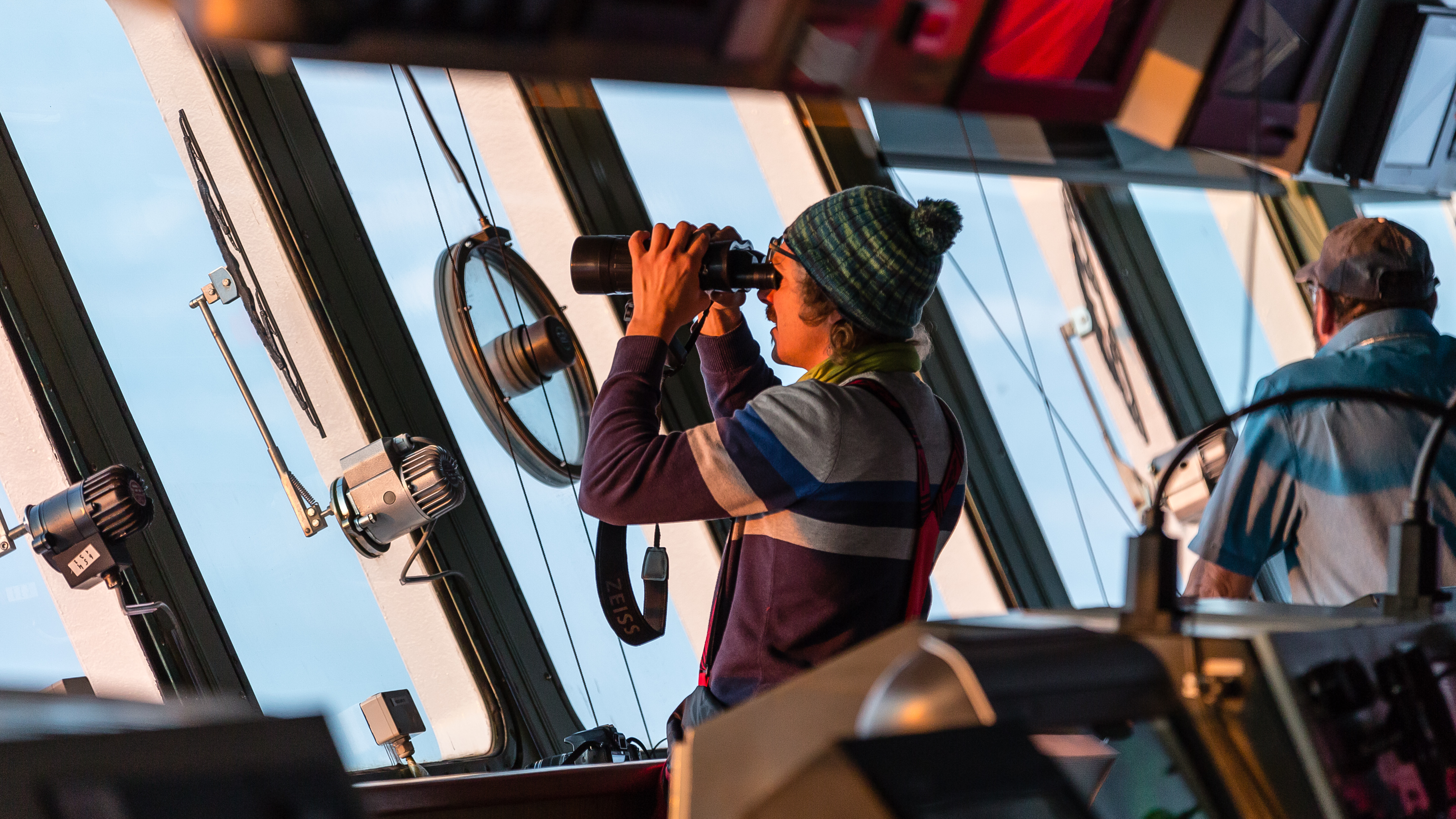
We are (were) all constantly working during (polar) night ; ). But for the scientists, the outdoor work usually takes place between 9 am and 5:30 pm, because during these hours we have the bear watch. Before and after the outdoor working hours there are meetings and people save and analyze their data. Parts of the ship’s crew work in shifts called 'watches' on board. For example, the nautical officers on the bridge are on watch two times for four hours: from 0 to 4 am and pm, from 4 to 8 am and pm, and from 8 to 12 am and pm. I just talked to one of them being on watch from 4:00 to 8:00 who told me, that for him this rhythm is no problem at all!
-Folke Mehrtens, Communications Office aboard the Polarstern during Leg II of the expedition
Photo (R): Thomas Sterbenz takes his turn on bridge watch; Photo credit: Stefan Hendricks
Jill from Middleton Middle School wants to know: What do you use as a power source for your equipment and ship?
The ship's diesel generators are our only source of power out on the ice and long power cables were installed to run the equipment at various sites out on the ice. Sometimes when the ice cracks open or ice ridges form the cables are trapped or damaged and we need to move them to new locations. This happend several times during leg 1. When the sun rises again a few remote instruments may be able to use solar power.
-Byron Blomquist, University of Colorado Boulder/NOAA, MOSAiC Team Atmosphere. Byron participated in Leg 1 of the expedition.
Send us your #askmosaic questions!
 This week's featured remote learning resources
NOVA Polar Lab
Something big is happening to Earth’s climate, and the polar regions hold the key to understanding it. Join top scientists in this immersive, multimedia experience on the hunt for clues that tell a surprising story about our planet’s past...and preview where we might be headed.
NOVA Polar Extremes
In this two-hour special, renowned paleontologist Kirk Johnson takes us on an epic adventure through time at the polar extremes of our planet. Following a trail of strange fossils found in all the wrong places—beech trees in Antarctica, hippo-like mammals in the Arctic—Johnson uncovers the bizarre history of the poles, from miles-high ice sheets to warm polar forests teeming with life.
UCAR Center for Science Education: Comparing maps of Arctic sea ice
Has has Arctic sea ice extent changed over time? Select maps of sea ice extent, courtesy of the National Snow and Ice Data Center, for a variety of months and years to compare how sea ice varies seasonally and over longer periods of time in the Arctic.
Live polar bear cam at Wapusk National Park, Manitoba, Canada
This polar bear cam is streaming from Cape Churchill in northern Manitoba's Wapusk National Park, home to one of the world's largest concentrations of polar bear maternity dens. In October and November, watch these bear families wait for sea ice--a critical hunting platform for polar bears--to form.
Observe polar bears on the live cam
Check out our full list of remote, online, and at-home learning resources on polar topics!
 MOSAiC Weekly Tracking
Plot the Polarstern
Each week we will provide you with the latitude and longitude coordinates of the Polarstern so that your students can track its journey across the Arctic in your classroom.
Download the map to plot coordinates
Download a larger map of the Arctic for a bigger picture view of the expedition area
Location of the Polarstern
| Date | Latitude | Longitude |
| September 16, 2019 | 69.68 N | 18.99 E |
| September 23, 2019 | 72.31 N | 26.93 E |
| September 30, 2019 | 85.12 N | 138.05 E |
| October 4, 2019** | 85.08 N | 134.43 E |
| October 7, 2019 | 85.10 N | 133.82 E |
| October 14, 2019 | 84.85 N | 135.03 E |
| October 21, 2019 | 84.97 N | 132.73 E |
| October 28, 2019 | 85.47 N | 127.07 E |
| November 4, 2019 | 85.88 N | 121.70 E |
| November 11, 2019 | 85.82 N | 116.00 E |
| November 18, 2019 | 86.05 N | 122.43 E |
| November 25, 2019 | 85.85 N | 121.35 E |
| December 2, 2019 | 85.97 N | 112.95 E |
| December 9, 2019 | 86.25 N | 121.40 E |
| December 16, 2019 | 86.62 N | 118.12 E |
| December 23, 2019 | 86.63 N | 113.20 E |
| December 30, 2019 | 86.58 N | 117.13 E |
| January 6, 2020 | 87.10 N | 115.10 E |
| January 13, 2020 | 87.35 N | 106.63 E |
| January 20, 2020 | 87.42 N | 97.77 E |
| January 27, 2020 | 87.43 N | 95.82 E |
| February 3, 2020 | 87.42 N | 93.65 E |
| February 10, 2020 | 87.78 N | 91.52 E |
| February 17, 2020 | 88.07 N | 78.52 E |
| February 24, 2020 | 88.58 N | 52.87 E |
| March 2, 2020 | 88.17 N | 31.02 E |
| March 9, 2020 | 87.93 N | 24.20 E |
| March 16, 2020 | 86.87 N | 12.70 E |
| March 23, 2020 | 86.20 N | 15.78 E |
| March 30, 2020 | 85.37 N | 13.27 E |
**Day when MOSAiC reached the ice floe that the Polarstern will become frozen in and drift with for the next year.
Log MOSAiC Data
Keep track of Arctic conditions over the course of the expedition:
Download Data Logbook for Sept. 2019 - Dec. 2019
Download Data Logbook for Dec. 2019 - Mar. 2020
*NEW* Download Data Logbook for Mar. 2020 - June 2020
--> If you are a student with an @gwsds email address and are requesting access to the new logbook, we are unable to give you access because of restrictions your school has put on your school account. Please contact your teacher and let them know so that they can download the logbook and email it to you directly.
| Date | Length of day (hrs) | Air temperature (deg C) at location of Polarstern | Arctic Sea Ice Extent (million km2) |
| September 16, 2019 | 13.25 | High: 10 Low: 4.4 | 3.9 |
| September 23, 2019 | 12.35 | High: 6 Low: -1 | 4.1 |
| September 30, 2019 | 9.1 | -4.7 | 4.4 |
| October 4, 2019** | 6.27 | -13.0 | 4.5 |
| October 7, 2019 | 3.05 | -8.2 | 4.6 |
| October 14, 2019 | 0 | -14.7 | 4.8 |
| October 21, 2019 | 0 | -12.8 | 5.4 |
| October 28, 2019 | 0 | -18.3 | 6.8 |
| November 4, 2019 | 0 | -18.9 | 8.0 |
| November 11, 2019 | 0 | -25.5 | 8.7 |
| November 18, 2019 | 0 | -10.7 | 9.3 |
| November 25, 2019 | 0 | -18.4 | 10.0 |
| December 2, 2019 | 0 | -26.6 | 10.4 |
| December 9, 2019 | 0 | -23.1 | 11.2 |
| December 16, 2019 | 0 | -19.2 | 11.8 |
| December 23, 2019 | 0 | -26.9 | 12.2 |
| December 30, 2019 | 0 | -26.4 | 12.6 |
| January 6, 2020 | 0 | -28.0 | 13.0 |
| January 13, 2020 | 0 | -30.7 | 13.1 |
| January 20, 2020 | 0 | -27.1 | 13.6 |
| January 27, 2020 | 0 | -22.5 | 13.8 |
| February 3, 2020 | 0 | -28.8 | 14.1 |
| February 10, 2020 | 0 | -26.2 | 14.5 |
| February 17, 2020 | 0 | -31.9 | 14.4 |
| February 24, 2020 | 0 | -24.0 | 14.6 |
| March 2, 2020 | 0 | -35.5 | 14.8 |
| March 9, 2020 | 0 | -37.9 | 14.7 |
| March 16, 2020 | 10.5 | -27.5 | 14.7 |
| March 23, 2020 | 16.5 | -28.7 | 14.4 |
| March 30, 2020 | 24 | -28.6 | 14.0 |
*Note: We expect data to fall within the following ranges: Length of day, 0-24 hours; Temperature, -40 to 14 degrees C; Sea ice extent, 3-15 million km2
**Day when MOSAiC reached the ice floe that the Polarstern will become frozen in and drift with for the next year.
Is there something you'd like to see in MOSAiC Monday? Let us know!
Send us your feedback
New to MOSAiC Monday? Check out past editions!
Browse more expedition-related educational resources, videos, and blogs
Email us! mosaic@colorado.edu