 and Thomas Rackow (left) are discussing the weather and visibility forecasts for 26 September 2019 (photo by Thea Schneider)")
-
Date
By MOSAiC School participants Mauro Hermann (Switzerland), Thea Schneider (Germany, and lecturer Thomas Rackow (Germany)
Predicting the weather is not an easy thing to do - we know that from everyday life. No rain predicted? Maybe take a jacket with you anyway, because the weather is a chaotic system. This means that even small initial perturbations can lead to a very different outcome. In weather prediction, numerical computer models are used. These models include available measurements from observational sites all over the world when they start their prediction. This so-called initialization can not be perfect, since we do not know the temperature and other important variables everywhere on our planet, but also because the measurements are not exact. This leads to small errors in the beginning, which can grow rapidly in forecasts of a chaotic system like our Earth’s atmosphere.
The computer models use the language of mathematics to calculate how our atmosphere, ocean, sea ice and other components will evolve through time. In the end, we get a prediction of temperature, wind speed, clouds, humidity, precipitation and so on for approximately the next two weeks.
To describe the evolution of the weather in a mathematical way, the processes that govern this evolution need to be fully understood. This is, however, not the case yet – which is especially true for the Arctic region. This is mostly due to of the lack of observations in this remote and extremely harsh region of our planet. Imagine your city and how many people are monitoring the weather. Now imagine the Central Arctic: sea ice and open ocean all around you and no settlement for more than 1000 km. How would you observe the weather there? This makes it really difficult for scientists to get continuous and reliable data to understand the processes that are connected to the unique interaction of sea ice, atmosphere, ocean and bio-geochemistry. This is why the MOSAiC expedition is so important for modellers. It will help us to better understand processes related to Arctic interactions and to translate them into a form our computer models can understand. Better process understanding will then lead to more reliable weather (and climate) models.
These are two of the difficulties related to predicting the weather in general. It is even harder if you are on a ship or research vessel, in the middle of the Arctic, with no general internet connection and only very limited remote access to the available data. As young scientists, one of our goals on board is to provide valuable weather information to the crew, pilots, and scientists in the daily General Meetings on board of RV Akademik Fedorov. The course of a typical meeting is outlined below.
Chairs are rumbling. Everyone is gathering in the mess hall, continuing lively discussions, and many tired faces are seen before the daily General Meeting after a long day on the ice. Our chief scientist Thomas Krumpen welcomes everyone, summarizes the accomplishments of the day, and soon hands over to the students of the MOSAiC School to present their weather forecast. The usual variables are temperature, humidity, sea level pressure and wind, but also sea ice concentration, cloud cover and vertical atmospheric profiles are of interest.
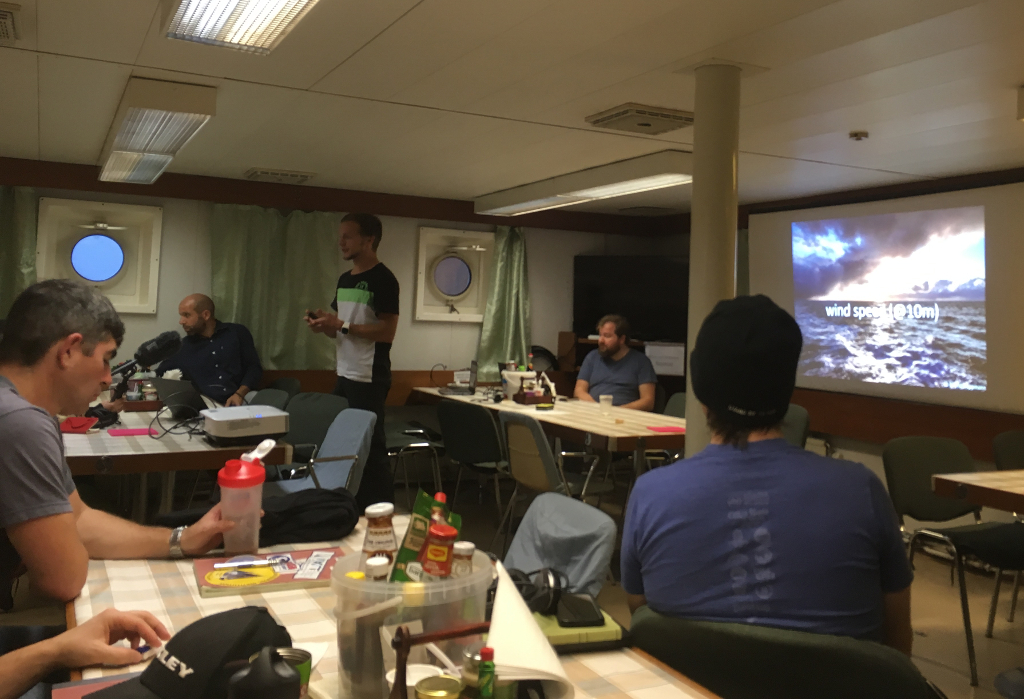
We started with a basic computer (Python) program to illustrate the basic data (temperature, humidity,…) from one of the best state-of-the-art global numerical weather prediction models – the Integrated Forecasting System from the European Centre for Medium-Range Weather Forecast (ECMWF). These basic illustrations had typically been used in the mornings to inform helicopter operations and the planning of deployments (see photo above).
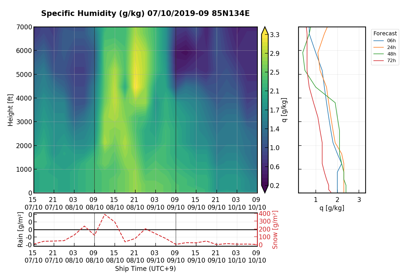
During the course of the expedition, we further refined the diagnostics over time and passed the knowledge on to our fellow MOSAiC School students. The meteorological office from Polarstern provided us with complementary large-scale sea level pressure maps and a text-based weather forecast, which greatly helped with the interpretation of the model data available to us. Being limited by the bandwidth of the satellite connection, the only feasible way is to download subsets of the global model forecasts just for our area of interest, which reduces file size drastically. The large-scale weather patterns over the entire Arctic are however important to better interpret the weather development over a few days and to put our more localized model information into context. An important refinement of the weather forecast was the vertical structure of the atmosphere, as this gives more detailed insight into ongoing processes (see image 1). We use the German Weather Service’s (DWD) predictions from their ICON atmosphere model for this purpose. With all that information, we then slip into the role of a meteorologist and combine all the different pieces, creating a comprehensive picture of the current and upcoming weather situation in our area of interest. That is, the area of the MOSAiC sea ice floe and the surrounding instruments and installations that are part of the so-called Distributed Network.
Having access to this kind of information is crucial for daily planning of the expedition, but also for the life on board of Akademik Fedorov. The number one news is typically the wind (see image below). Blowing snow and high values of relative humidity in the air affect the visibility, which is crucial for helicopter flights and the polar bear watch. Without the ability to identify approaching polar bears, nobody is allowed to set foot on the ice floe for L-site deployment. Further, when travelling on open waters, the winds determine ocean wave height and thus the safety and comfort of the passengers on board. To really pin down visibility, we further need to predict the occurrence of snowfall, near-surface fog, and low-level clouds. The latter are especially important for the helicopter operations to set up the smaller M-sites of the MOSAiC Distributed Network. Another important variable to consider for working outside is the temperature, which has been as low as -16°C today with wind chill up to -25°C. You can get frostbite very easily and it is important to watch one another.
Today we were lucky, as the sky cleared just in time. Tomorrow will be the first day where the sun will not rise above the horizon. The polar night has begun.
This is a contribution from participants of the MOSAiC School, Mauro Hermann (ETH Zürich, Institute for Atmospheric and Climate Science), Thea Schneider (YOPP / University Potsdam), and lecturer Thomas Rackow (YOPP / Alfred Wegener Institute, Helmholtz Centre for Polar and Marine Research). The MOSAiC School is a 7-week training for 20 early-career researchers organized by APECS and AWI. Substantial support was received from ARICE and IASC.