Science On, In, and Under the Ice
The MOSAiC expedition, which began last fall, will continue through October 2020. This will allow scientists to study the Arctic climate system over a full annual seasonal cycle. Leg 4 participants are experiencing a drastically different Arctic from MOSAiC team members who were on board the Polarstern back in January. Summertime in the central Arctic means 24 hours of sunlight and average temperatures hovering right around freezing, while six months ago things were MUCH darker and MUCH colder.
What does this seasonal shift in sunlight and warmer temperatures mean for the Arctic and for leg 4 scientists? Here is some insight from the MOSAiC science teams:
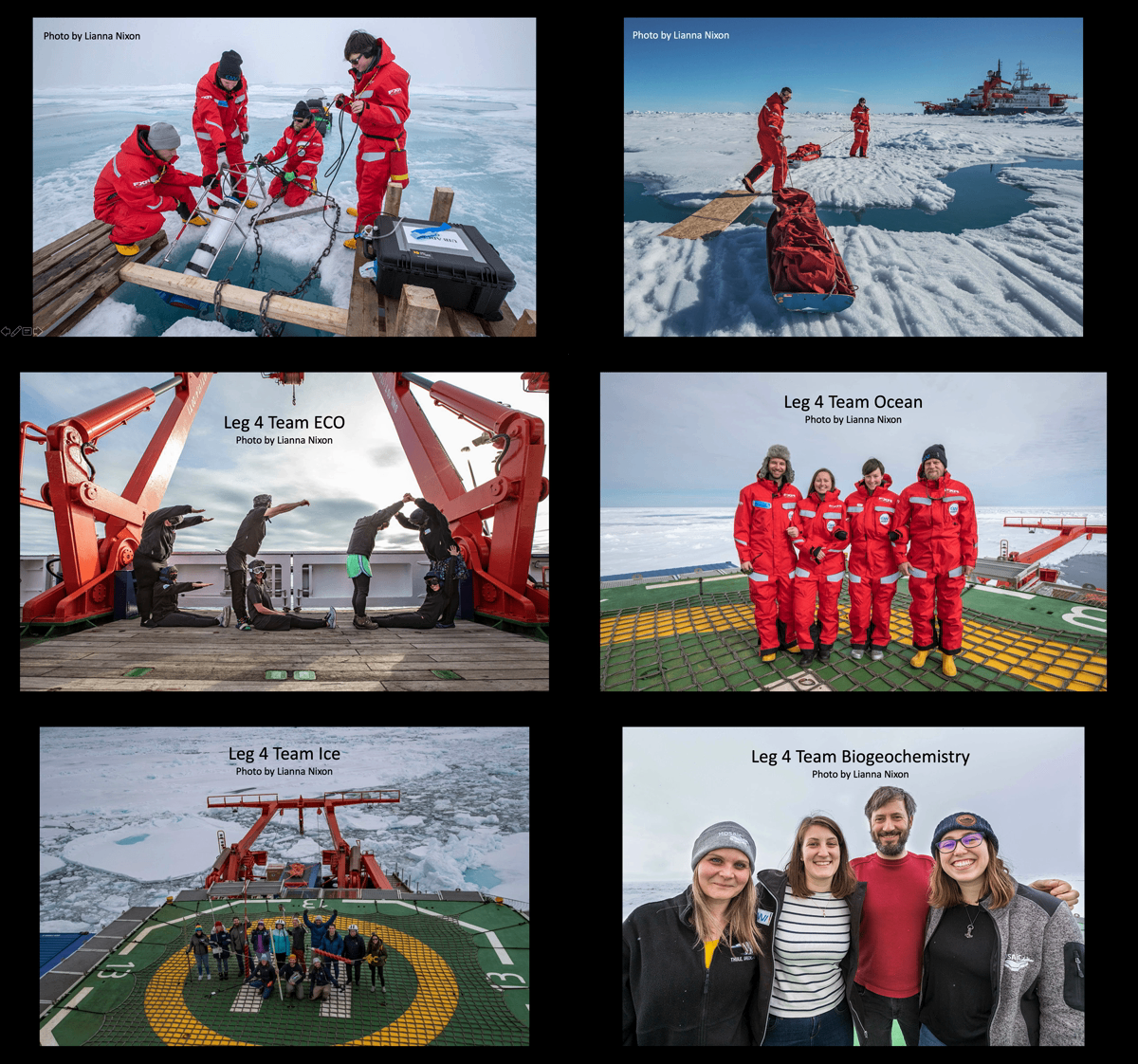
"Changes are happening on all scales at our research camp site! Since we arrived at the floe, our white snow-covered MOSAiC floe with a few melt ponds has changed to a much wetter landscape."
"We are eager to continue time series measurements, but with a special focus for this time of year: capturing the biological and ecological changes occurring in sea ice and seawater in response to the 24 hours of sunlight and the onset of melt." -Team ECOsystems
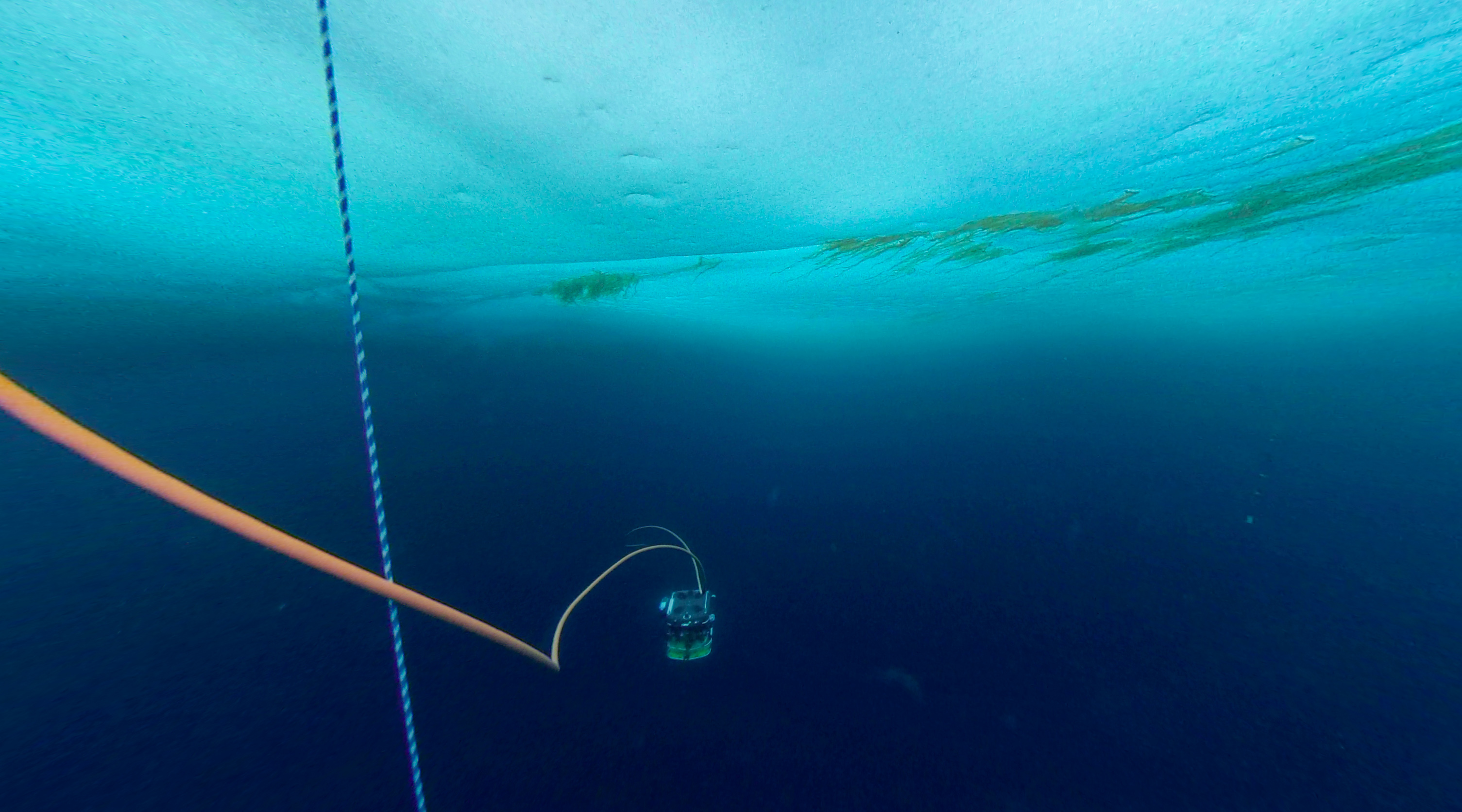
"The ICE team has deployed the ROV (remotely operated vehicle) named "Beast" underneath the ice. The ROV has 16 sensors to measure ice conditions, light availability, and water column properties. It also has a multi beam scanning sonar for profiling the ice bottom topography, sensors that measure water properties like water pH and a CTD to measure the conductivity (C), temperature (T), depth (D) of the ocean." -Team ICE
"The long-range Acoustic Doppler Current Profiler (ADCP) is running! The instrument is placed underneath the sea ice and measures current velocities and direction in different layers of the ocean. This information is important in helping MOSAiC scientists understand how the ocean current transports heat and nutrients throughout the Arctic Ocean." -Team OCEAN
Photo: A view from the eyes of the Beast; Photo credit: Lianna Nixon
Read MOSAiC team member blogs
 #askmosaic: Nicebreaker?
This week's question: Is the ship fancy?
"For us scientists Polarstern is a very “fancy” ship because of all its scientific installations, the well-experienced crew and a good atmosphere. It provides almost everything we could wish for. However it is not “fancy” as compared to a luxurious cruise ship. For us, a cruise vessel would not be fancy at all, because it would not provide us with big cranes, electricians to fix our devices or highly specialized computer networks. We do have a pool and a sauna, but this is definitely not comparable to a wellness temple on a fancy cruise vessel."
-Christian Katlein, Team ICE, Alfred Wegener Institute
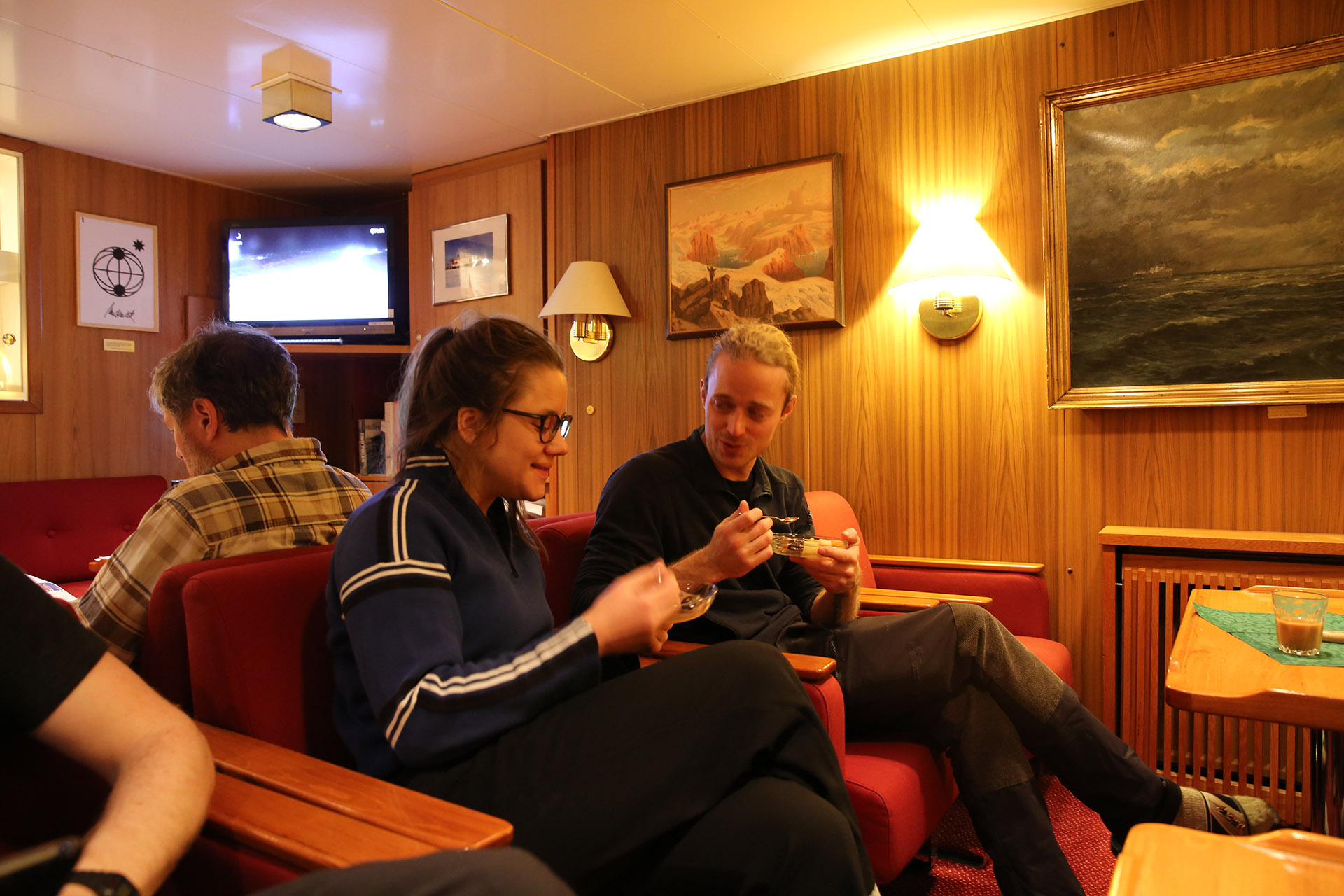
Photo: MOSAiC team members relax in the Polarstern's red salon; Photo credit: Folke Mehrtens
Want to check out the "fancy" Polarstern for yourself? Take the 360-degree tour!
Send us your #askmosaic questions!
 MOSAiC Virtual Summer Camp
Did you or your kids have summer camp plans that fell through because of COVID? Not to worry! Tune in to MOSAiC Monday each week for a fun, hands-on and engaging virtual summer camp activity related to MOSAiC or the Arctic. All MVSC activities should be done with parent supervision!
This Week's Activity: Shoot for the Stars
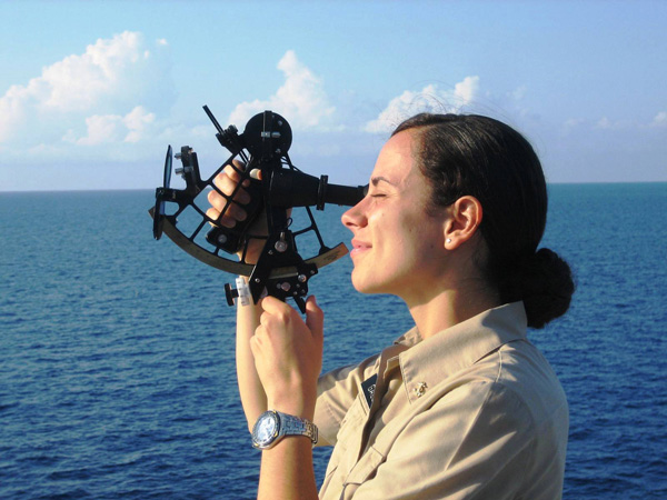
Modern ships like the Polarstern use advanced technology like satellite systems (for example, GPS) to figure out where they are and where they are going. When Fridtjof Nansen and his crew set out into the frozen Arctic in 1893 on board the Fram, they didn't have such advanced tools and technology for figuring out how to get around. Instead they used instruments like the sextant to navigate. You can make your own sextant from simple materials you might be able to find at home! Photo of person using sextant for navigation at sea: Bernie Bernard TDI-Brooks International, Inc.
What you will need:
- Protractor
- String (~9 inches long)
- Paper clips
- Tape
- Foot-long ruler
- Small weighted object with a hole, such as a key or metal washer
What to do:
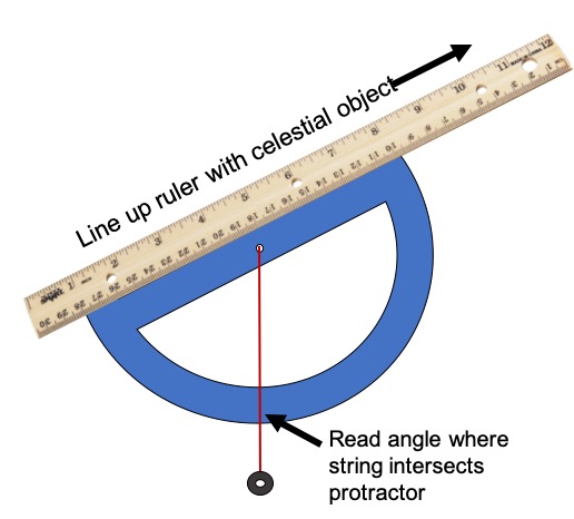
- Tie the small weighted object to one end of the string.
- Tie the other end of the string to the midpoint of the protractor (there is often a hole at the midpoint that you can thread the string though, or just wrap it around the protractor's base).
- Tape the protractor to the ruler so that one end of the protractor is at the 1 inch mark of the ruler - see picture.
- Turn the sextant so that the protractor is pointing down and the string with the weighted object hangs down over the protractor.
What is the latitude of the place where you currently are? If you are in the Northern Hemisphere, you can figure this out by going outside on a clear evening when the Little Dipper constellation is in the sky. Hold your sextant up to your eye so that the long part of the ruler is facing away from you and line it up with Polaris, the star at the end of the Little Dipper's handle. Read the angle off of the protractor that the string lines up with, and subtract this number from 90 degrees. The resulting number is your latitude! If you are in the Southern Hemisphere, use the constellations Centaurus and Crux. Draw an imaginary line between the two brightest stars in Centaurus, then another line bisecting it. The point where the bisecting line crosses a line drawn through Crux is the southern pole. Treat the southern pole like Polaris and measure your latitude.
This activity was adapted from "How to make a sextant from random junk" featured in Popular Science
Check out our full list of virtual and at-home polar learning resources here!
 Educators' Corner
The school year has ended for most K-12 students and teachers in many places, which means that it's time for professional development workshops, fall curriculum planning, and hopefully a bit of relaxation time! Each week throughout the summer, we'll use Educators' Corner to highlight MOSAiC and Arctic-related lessons, multimedia resources, and other educational materials that you can use in your NGSS (or similar) classroom, in person or remotely. Are you looking for a particular kind of educational resource? Let us know! Email us at mosaic@colorado.edu.
For Your Classroom: 1893-1896 Fram Expedition to the Arctic
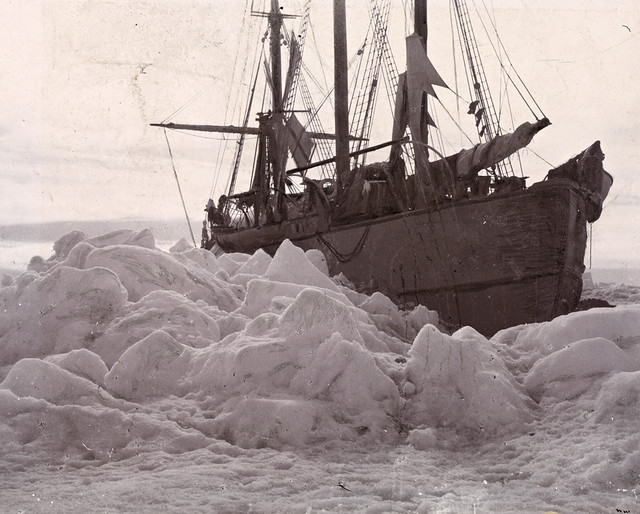
The 1893-1896 Fram expedition was the first attempt to reach the North Pole by freezing a ship in sea ice and drifting with ocean currents. While the crew was unsuccessful in their goal of reaching the North Pole, their persistence, imagination, and creativity as scientists and explorers helped them safely navigate the Arctic as they returned to Norway after three years aboard the Fram, having gathered more information about the polar region than anyone before them. Expeditions like the Fram and MOSAiC are great ways to engage your students in STEM learning as they anchor learning within a compelling and exciting context. They also allow students to experience STEM learning like scientists and gain a better and more realistic understanding of the process and nature of science. Photo of the Fram in ice: National Library of Norway
In this lesson for middle and high school classrooms, students experience the 1893 Fram expedition through a virtual reality Google Expedition and learn why science is truly a human endeavor. This lesson connects with the following NGSS standards:
- Science is a Human Endeavor: Scientists and engineers rely on human qualities such as persistence, precision, reasoning, logic, imagination and creativity
- NGSS Science and Engineering Practices: Obtaining, evaluating, and communicating information
Go to lesson: Fram Motivation
Educators: Sign up now for MOSAiC Expedition Virtual Teacher Workshops in July and August!
Workshop 1: New & Old Arctic
When: July 28-29 10 am - 2 pm MT
Where: Your living room
Cost: Free!
What you get: Certificate for 10 hours of professional development with the option to pay for 1 graduate credit from CU Boulder
Workshop 2: Arctic Feedbacks: Not All Warming is Equal
When: August 4-5 10 am - 2 pm MT
Where: Your living room
Cost: Free!
What you get: Certificate for 10 hours of professional development and 1 graduate credit from CU Boulder (paid for by CIRES)
 MOSAiC Weekly Tracking
Plot the Polarstern
Each week we will provide you with the latitude and longitude coordinates of the Polarstern so that you can track its journey across the Arctic.
Download the map to plot coordinates
Download a larger map of the Arctic for a bigger picture view of the expedition area
Location of the Polarstern
| Date | Latitude | Longitude |
| September 16, 2019 | 69.68 N | 18.99 E |
| September 23, 2019 | 72.31 N | 26.93 E |
| September 30, 2019 | 85.12 N | 138.05 E |
| October 4, 2019** | 85.08 N | 134.43 E |
| October 7, 2019 | 85.10 N | 133.82 E |
| October 14, 2019 | 84.85 N | 135.03 E |
| October 21, 2019 | 84.97 N | 132.73 E |
| October 28, 2019 | 85.47 N | 127.07 E |
| November 4, 2019 | 85.88 N | 121.70 E |
| November 11, 2019 | 85.82 N | 116.00 E |
| November 18, 2019 | 86.05 N | 122.43 E |
| November 25, 2019 | 85.85 N | 121.35 E |
| December 2, 2019 | 85.97 N | 112.95 E |
| December 9, 2019 | 86.25 N | 121.40 E |
| December 16, 2019 | 86.62 N | 118.12 E |
| December 23, 2019 | 86.63 N | 113.20 E |
| December 30, 2019 | 86.58 N | 117.13 E |
| January 6, 2020 | 87.10 N | 115.10 E |
| January 13, 2020 | 87.35 N | 106.63 E |
| January 20, 2020 | 87.42 N | 97.77 E |
| January 27, 2020 | 87.43 N | 95.82 E |
| February 3, 2020 | 87.42 N | 93.65 E |
| February 10, 2020 | 87.78 N | 91.52 E |
| February 17, 2020 | 88.07 N | 78.52 E |
| February 24, 2020 | 88.58 N | 52.87 E |
| March 2, 2020 | 88.17 N | 31.02 E |
| March 9, 2020 | 87.93 N | 24.20 E |
| March 16, 2020 | 86.87 N | 12.70 E |
| March 23, 2020 | 86.20 N | 15.78 E |
| March 30, 2020 | 85.37 N | 13.27 E |
| April 6, 2020 | 84.52 N | 14.38 E |
| April 13, 2020 | 84.28 N | 14.97 E |
| April 20, 2020 | 84.52 N | 14.57 E |
| April 27, 2020 | 83.93 N | 15.65 E |
| May 4, 2020 | 83.92 N | 18.03 E |
| May 11, 2020 | 83.47 N | 13.08 E |
| May 18+, 2020 | 83.32 N | 8.68 E |
| May 25+, 2020 | 82.43 N | 8.28 E |
| June 1+, 2020 | 81.33 N | 9.93 E |
| June 8+, 2020 | 78.10 N | 12.73 E |
| June 15+, 2020 | 82.20 N | 8.18 E |
| June 22, 2020 | 81.95 N | 9.27 E |
| June 29, 2020 | 82.03 N | 9.88 E |
| July 6, 2020 | 81.67 N | 5.22 E |
**Day when MOSAiC reached the ice floe that the Polarstern will become frozen in and drift with for the next year.
+ Indicates when the Polarstern traveled under its own engine power (no drifting)
Log MOSAiC Data
Keep track of Arctic conditions over the course of the expedition:
Download Data Logbook for Sept. 2019 - Dec. 2019
Download Data Logbook for Dec. 2019 - Mar. 2020
Download Data Logbook for Mar. 2020 - June 2020
*New* Download Data Logbook for July 2020 - Oct. 2020
| Date | Length of day (hrs) | Air temperature (deg C) at location of Polarstern | Arctic Sea Ice Extent (million km2) |
| September 16, 2019 | 13.25 | High: 10 Low: 4.4 | 3.9 |
| September 23, 2019 | 12.35 | High: 6 Low: -1 | 4.1 |
| September 30, 2019 | 9.1 | -4.7 | 4.4 |
| October 4, 2019** | 6.27 | -13.0 | 4.5 |
| October 7, 2019 | 3.05 | -8.2 | 4.6 |
| October 14, 2019 | 0 | -14.7 | 4.8 |
| October 21, 2019 | 0 | -12.8 | 5.4 |
| October 28, 2019 | 0 | -18.3 | 6.8 |
| November 4, 2019 | 0 | -18.9 | 8.0 |
| November 11, 2019 | 0 | -25.5 | 8.7 |
| November 18, 2019 | 0 | -10.7 | 9.3 |
| November 25, 2019 | 0 | -18.4 | 10.0 |
| December 2, 2019 | 0 | -26.6 | 10.4 |
| December 9, 2019 | 0 | -23.1 | 11.2 |
| December 16, 2019 | 0 | -19.2 | 11.8 |
| December 23, 2019 | 0 | -26.9 | 12.2 |
| December 30, 2019 | 0 | -26.4 | 12.6 |
| January 6, 2020 | 0 | -28.0 | 13.0 |
| January 13, 2020 | 0 | -30.7 | 13.1 |
| January 20, 2020 | 0 | -27.1 | 13.6 |
| January 27, 2020 | 0 | -22.5 | 13.8 |
| February 3, 2020 | 0 | -28.8 | 14.1 |
| February 10, 2020 | 0 | -26.2 | 14.5 |
| February 17, 2020 | 0 | -31.9 | 14.4 |
| February 24, 2020 | 0 | -24.0 | 14.6 |
| March 2, 2020 | 0 | -35.5 | 14.8 |
| March 9, 2020 | 0 | -37.9 | 14.7 |
| March 16, 2020 | 10.5 | -27.5 | 14.7 |
| March 23, 2020 | 16.5 | -28.7 | 14.4 |
| March 30, 2020 | 24 | -28.6 | 14.0 |
| April 6, 2020 | 24 | -18.2 | 13.7 |
| April 13, 2020 | 24 | -25.8 | 13.6 |
| April 20, 2020 | 24 | -10.2 | 13.3 |
| April 27, 2020 | 24 | -11.7 | 12.8 |
| May 4, 2020 | 24 | -16.2 | 12.8 |
| May 11, 2020 | 24 | -10.4 | 12.4 |
| May 18, 2020 | 24 | -5.1 | 11.7 |
| May 25, 2020 | 24 | 0.4 | 11.5 |
| June 1, 2020 | 24 | 0.0 | 11.1 |
| June 8+, 2020 | 24 | -0.1 | 10.6 |
| June 15+, 2020 | 24 | -0.4 | 10.1 |
| June 22, 2020 | 24 | -0.4 | 9.6 |
| June 29, 2020 | 24 | 0.5 | 9.2 |
| July 6, 2020 | 24 | 0.6 | 8.2 |
*Note: We expect data to fall within the following ranges: Length of day, 0-24 hours; Temperature, -40 to 14 degrees C; Sea ice extent, 3-15 million km2
**Day when MOSAiC reached the ice floe that the Polarstern will become frozen in and drift with for the next year.
Is there something you'd like to see in MOSAiC Monday? Let us know!
Send us your feedback
New to MOSAiC Monday? Check out past editions!
Browse more expedition-related educational resources, videos, and blogs
Email us! mosaic@colorado.edu

