K-2

Route of the Fram Expedition (1893-1896)
On July 5th, 1893, the Fram set sail from Tromsø, Norway to try to reach the highest latitude ever attained. Fridtjof Nansen, leader of the Fram expedition, attempted to freeze a custom-built wooden ship in sea ice and use Arctic currents to drift north. See where the Fram--and Nansen--drifted and dogsledded during their three years in the Arctic.
Project of Mosaic Data visualization
Subject: Expeditions, Geography, Oceans and ocean circulation
Grade Level: K-2, 3-5, Middle School, High School, University/college
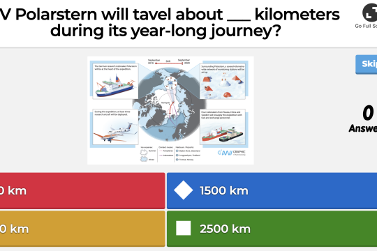
MOSAiC in Numbers Trivia
What temperatures will the MOSAiC researchers endure during the expedition? How far with the Polarstern drift during its 13 month journey? Introduce your students to the MOSAiC expedition and count down to the expedition launch with this MOSAiC in Numbers trivia quiz.
Project of Mosaic Game
Subject: Expeditions
Grade Level: K-2, 3-5, Middle School, High School
Developer: CIRES
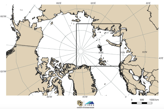
Where is the Arctic?
Have your students label and color the countries around the Arctic and do some research about the various people who live in the Arctic region. How is the 'Arctic' defined geographically? Note: We suggest using the this map in conjunction with the "Tracking the Polarstern" map (download both maps and copy them front to back for your students). The inset box on the "Where is the Arctic?" map shows the boundaries for the "Tracking the Polarstern" map.
Project of Mosaic Quick bite
Subject: Geography
Grade Level: K-2, 3-5, Middle School, High School, University/college
Developer: CIRES
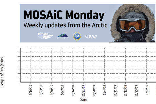
MOSAiC Data Logbook
Your students can be MOSAiC scientists by analyzing real-time data from the expedition each week. Download the MOSAiC Data Log Book and look for the data in each MOSAiC Monday newsletter throughout the expedition. Over time, your students will be able to use the data they've graphed to make interpretations about seasonality in the Arctic and Arctic weather conditions. *Note: We expect data to fall within the following ranges: Length of Day: 0 to 24 hours Temperature: -40 to 14 °C Sea Ice Extent: 3 to 15 million km2 Download the MOSAiC Data Log Book
Project of Mosaic Quick bite
Subject: Analyzing and interpreting data, Earth science, Expeditions
Grade Level: K-2, 3-5, Middle School, High School, University/college
Developer: CIRES
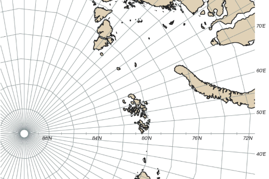
Tracking the Polarstern
The route that the Polarstern will take across the Central Arctic is not fully known. Since the ship will be frozen in the Arctic sea ice and drifting along with it wherever it goes, we can only make predictions about the path will follow. Each week we will provide you with the latitude and longitude coordinates of the Polarstern so that your students can track its journey across the Arctic in your classroom. Download this map and plot your first set of coordinates!
Project of Mosaic Quick bite
Subject: Expeditions, Geography
Grade Level: K-2, 3-5, Middle School, High School, University/college
Developer: CIRES