Earth science
Quick Bite: Arctic Current Events
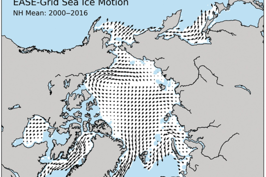
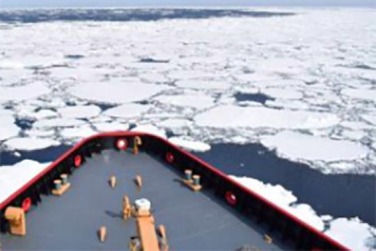
Can you identify currents in the Arctic Ocean using ocean motion vector maps? Figure credit: NASA/NSIDC/DAAC/University of Colorado Tschudi, Meier, Stewart
Quick bite
Subject: Earth science, mosaic monday, Oceans and ocean circulation
Grade Level: High School
Developer: CIRES
Can you identify currents in the Arctic Ocean using ocean motion vector maps? Figure credit: NASA/NSIDC/DAAC/University of Colorado Tschudi, Meier, Stewart
Quick bite
Subject: Earth science, mosaic monday, Oceans and ocean circulation
Grade Level: High School
Developer: CIRES
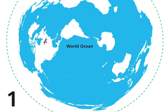
Quick Bite: The Arctic vs. the World
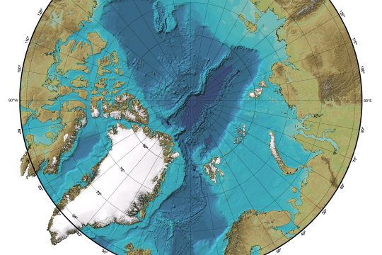
How does the Arctic Ocean's bathymetry compare to Earth's other ocean basins? Learn more in this Quick Bite activity.
Project of Mosaic Quick bite
Subject: Earth science, Geography, mosaic monday, Oceans and ocean circulation
Grade Level: Middle School, High School
Developer: CIRES
How does the Arctic Ocean's bathymetry compare to Earth's other ocean basins? Learn more in this Quick Bite activity.
Project of Mosaic Quick bite
Subject: Earth science, Geography, mosaic monday, Oceans and ocean circulation
Grade Level: Middle School, High School
Developer: CIRES
Quick Bite: Clouds in the Summer, Clouds in the Winter?
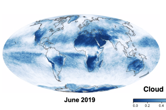
Is there seasonal variation in cloud cover in the Arctic? Learn more in this Quick Bite activity. Figure credit: NASA Earth Observatory
Quick bite
Subject: Analyzing and interpreting data, Atmosphere, Earth science, mosaic monday
Grade Level: Middle School, High School
Developer: CIRES
Is there seasonal variation in cloud cover in the Arctic? Learn more in this Quick Bite activity. Figure credit: NASA Earth Observatory
Quick bite
Subject: Analyzing and interpreting data, Atmosphere, Earth science, mosaic monday
Grade Level: Middle School, High School
Developer: CIRES
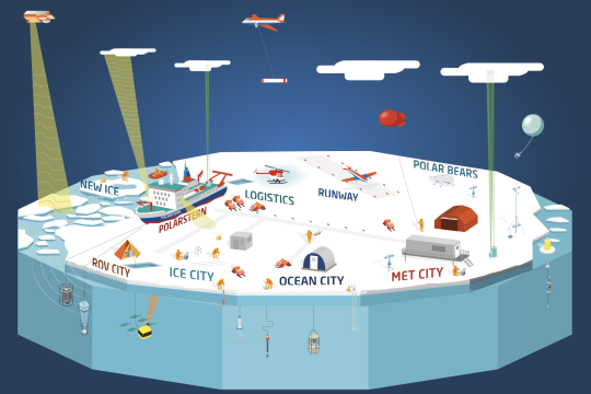
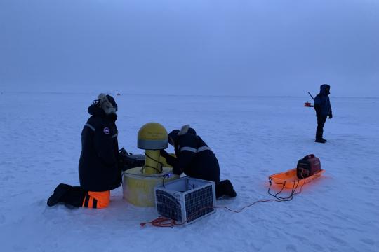
Quick Bite: How did MOSAiC scientists study the Arctic atmosphere?
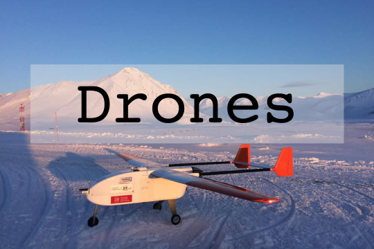
Learn about the various instruments scientists used to study the atmosphere during the 2019-2020 MOSAiC expedition in this Quick Bite activity.
Project of Mosaic Quick bite
Subject: Atmosphere, Earth science, Engineering and technology, Expeditions, mosaic monday, Physical science
Grade Level: Middle School, High School
Developer: CIRES
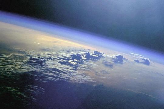
Quick Bite: Alien Atmospheres
Do other planets in our solar system have atmospheres? If so, how to they compare to Earth's? Find out in this Quick Bite activity. Photo credit: NASA
Quick bite
Subject: Atmosphere, Earth science, mosaic monday, Obtaining and evaluating information
Grade Level: Middle School, High School
Developer: CIRES
Quick Bite: Climate is a System
In this Quick Bite activity, your students will explore how Earth's systems are interconnected by becoming members of the 2019-2020 MOSAiC expedition science teams.
Project of Mosaic Quick bite
Subject: Climate, Earth science, Expeditions, mosaic monday
Grade Level: Middle School, High School
Developer: CIRES
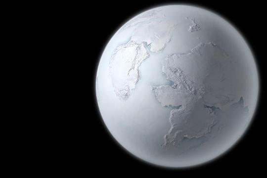
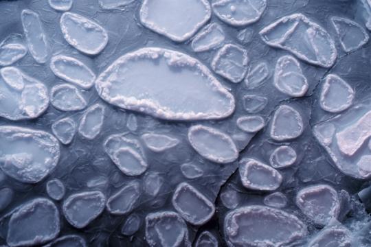
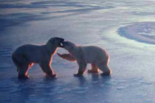
Quick Bite: Melting Ice-Albedo Feedback
Sea ice extent in the Arctic is on the decline. Could the opposite of a Snowball Earth happen? Figure credit: MIKKEL JUUL JENSEN/SPL/COSMOS
Project of Mosaic Quick bite
Subject: Arguing from evidence, Climate, Earth science, mosaic monday, Sea ice
Grade Level: Middle School, High School, University/college
Developer: CIRES
Quick Bite: Radiation Correlation?
This short activity will help your students start to connect the concept of albedo to the Arctic and Earth's climate.
Quick bite
Subject: Climate, Constructing explanations, Earth science, mosaic monday, Sea ice
Grade Level: Middle School, High School
Developer: CIRES
This short activity will help your students start to connect the concept of albedo to the Arctic and Earth's climate.
Quick bite
Subject: Climate, Constructing explanations, Earth science, mosaic monday, Sea ice
Grade Level: Middle School, High School
Developer: CIRES

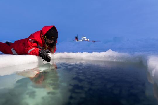
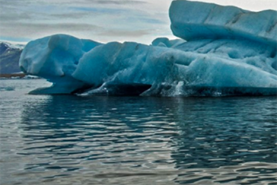
Quick Bite: Albedo Comparison
How do you think the average albedo of the Arctic compares to the average albedo of the entire Earth? Photo credit: Michael Gutsche/AWI
Quick bite
Subject: Arguing from evidence, Earth science, mosaic monday
Grade Level: Middle School, High School
Developer: CIRES
How do you think the average albedo of the Arctic compares to the average albedo of the entire Earth? Photo credit: Michael Gutsche/AWI
Quick bite
Subject: Arguing from evidence, Earth science, mosaic monday
Grade Level: Middle School, High School
Developer: CIRES
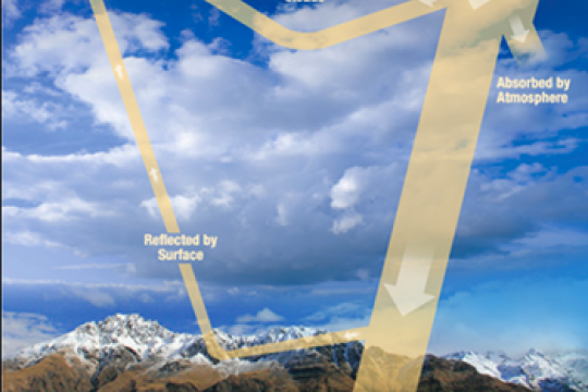
Quick Bite: Budget Your Money, Budget Your Energy
Just like you and I might have a financial budget, Earth has an energy budget. In this Quick Bite activity, students will explore this energy budget and what happens if it changes. Photo credit: Stefan Hendricks/AWI
Project of Mosaic Quick bite
Subject: Atmosphere, Climate, Developing and using models, Earth science, mosaic monday
Grade Level: Middle School, High School, University/college
Developer: CIRES
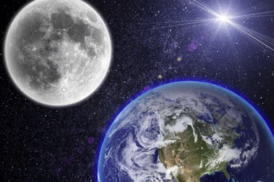
Quick Bite: Earth vs. Moon
Why are the Moon and Earth so different temperature-wise if they are essentially the same distance from the Sun?
Quick bite
Subject: Atmosphere, Climate, Constructing explanations, Earth science, mosaic monday
Grade Level: 3-5, Middle School, High School
Developer: CIRES
Why are the Moon and Earth so different temperature-wise if they are essentially the same distance from the Sun?
Quick bite
Subject: Atmosphere, Climate, Constructing explanations, Earth science, mosaic monday
Grade Level: 3-5, Middle School, High School
Developer: CIRES
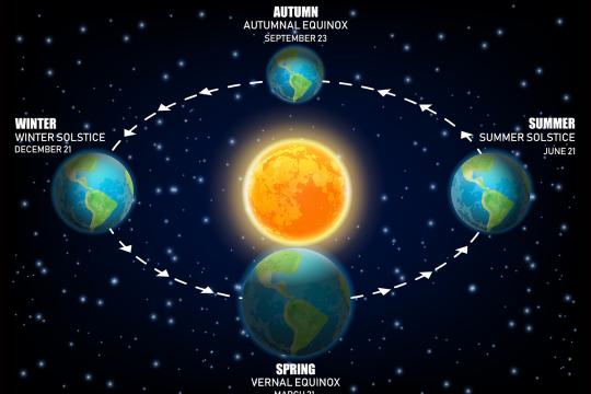
Quick Bite: What is the Winter Solstice?
What is the winter solstice? Construct your explanation after watching a video of the earth as it orbits the Sun.
Project of Mosaic Quick bite
Subject: Developing and using models, Earth science, mosaic monday
Grade Level: Middle School, High School
Developer: CIRES
What is the winter solstice? Construct your explanation after watching a video of the earth as it orbits the Sun.
Project of Mosaic Quick bite
Subject: Developing and using models, Earth science, mosaic monday
Grade Level: Middle School, High School
Developer: CIRES
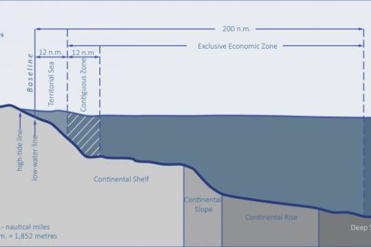
Quick Bite: Planting a Flag in the Arctic: Not so EEZ
To claim underwater territory, coastal nations must first understand their nearshore seafloor geology. In this short activity, your students will examine maps of Arctic Ocean bathymetry and identify continental shelves of the Arctic coastal nations.
Project of Mosaic Quick bite
Subject: Earth science, Geography, Geopolitics, mosaic monday
Grade Level: Middle School, High School, University/college
Developer: CIRES
Quick Bite: Daylight to Darkness: Constructing an Explanation
Why does the amount of daylight the Arctic region gets throughout the year vary so much more than regions at lower latitudes? In this Quick Bite activity, students use an online interactive simulation to explore this question.
Project of Mosaic Quick bite
Subject: Constructing explanations, Developing and using models, Earth science, mosaic monday
Grade Level: Middle School, High School
Developer: CIRES

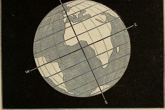
Quick Bite: (Re)Defining the Arctic
There are several ways to define the Arctic region geographically. In this Quick Bite activity, students will explore how a changing climate could change these geographic definitions.
Project of Mosaic Quick bite
Subject: Climate, Constructing explanations, Earth science, Geography, mosaic monday
Grade Level: Middle School, High School, University/college
Developer: CIRES
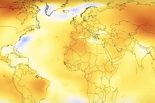
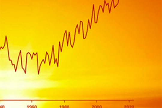
Quick Bite: You're Getting Warmer...
Looking at how global temperatures have changed over time can give us valuable insight into our planet's health. In this Quick Bite activity, students watch an animation of global temperature anomalies over time to discover that something strange is going on in the Arctic.
Project of Mosaic Quick bite
Subject: Analyzing and interpreting data, Climate, Earth science, Geography, mosaic monday
Grade Level: Middle School, High School, University/college
Developer: CIRES
Quick Bite: Climate in the Arctic
Why is the Arctic so much colder than the equator? What is the role of sunlight in the Arctic climate system? Explore these questions in this Quick Bite activity.
Project of Mosaic Quick bite
Subject: Asking questions, Climate, Constructing explanations, Earth science, mosaic monday
Grade Level: Middle School, High School
Developer: CIRES
Quick Bite: What is Climate?
What is climate? In this activity, your students will explore the differences between climate and weather to try to answer this question.
Project of Mosaic Quick bite
Subject: Climate, Earth science, Geography, mosaic monday
Grade Level: Middle School, High School
Developer: CIRES
What is climate? In this activity, your students will explore the differences between climate and weather to try to answer this question.
Project of Mosaic Quick bite
Subject: Climate, Earth science, Geography, mosaic monday
Grade Level: Middle School, High School
Developer: CIRES
Tracking Ice: Arctic Sea Ice and Mathematics Curriculum
Through the course of four modules, students will estimate the accuracy of their forecast and determine if it is fit for the purpose of guiding a search and rescue mission. After building their forecasting model, students will know how to access the coordinates of buoys tracked by the International Arctic Buoy Program (IABP) to make a sea ice drift forecast.
Lesson plan
Subject: Climate, Computational thinking, Developing and using models, Earth science, Oceans and ocean circulation, Sea ice
Grade Level: High School
Developer: SMILE Oregon State
Learn About the Equinox
Before she left to spend several weeks in the Arctic Ocean aboard an icebreaker on the MOSAiC expedition, PolarTREC educator Katie Gavenus put together a collection of educational resources for teaching about the equinox. Whether you're a fan of kinesthetic activities, art, or video lessons, there's something here for you!
Lesson plan
Subject: Constructing explanations, Developing and using models, Earth science
Grade Level: 3-5, Middle School, High School
Know Your Ocean: Polar Research
Learn more about polar topics like glaciers and ice sheets, Arctic sea life, and sea ice in these polar research educational modules from the Woods Hole Oceanographic Institution.
Subject: Earth science, Ecosystems, Geography, Life science, Obtaining and evaluating information, Oceans and ocean circulation, Physical science, Sea ice
Grade Level: Middle School, High School, University/college, Adult
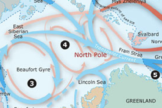
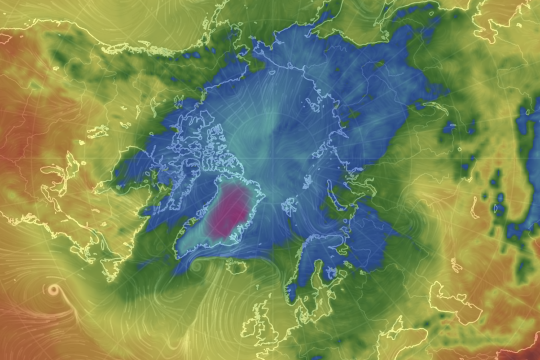
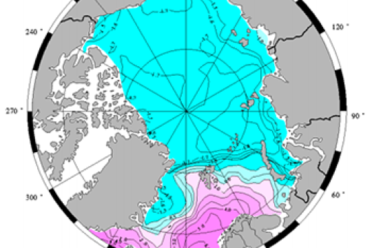
Polar Discovery: Arctic Ocean Circulation
The Arctic Ocean is a unique part of the globe, covered by ice much of the year and fairly isolated from the other oceans. Learn about how water in the Arctic Ocean moves around and why using this interactive graphic from the Woods Hole Oceanographic Institution.
Data visualization
Subject: Earth science, Geography, Obtaining and evaluating information, Oceans and ocean circulation, Physical science
Grade Level: Middle School, High School, University/college, Adult
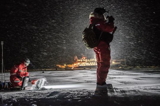
Timing an Arctic Expedition
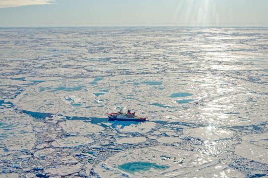
The MOSAiC (Multidisciplinary Drifting Observatory for the Study of Arctic Climate) expedition officially launched on September 20, 2019 when the icebreaker Polarstern set sail from Tromsø, Norway. The Polarstern will be looking for an ice floe that it can freeze into and drift along with across the Arctic for a year. The ice must be thick enough throughout the year to support the scientists and instruments that will be on it, but close to thinner ice that is easy to drill through. Why did the MOSAiC expedition begin in September? It turns out this isn't random, but a strategically chosen departure date. Challenge your students to use the National Snow and Ice Data Center's Charctic Interactive Sea Ice Graph to come up with an answer to this question. Then, read more about this question here. Photo: M. Van Woert, NOAA
Project of Mosaic Quick bite
Subject: Constructing explanations, Earth science, Expeditions, mosaic monday, Oceans and ocean circulation, Sea ice
Grade Level: Middle School, High School, University/college, Adult
Developer: CIRES
Project PARKA (Planting AntaRtica in KAnsas)
Explore this unit composed of four lessons designed to provide high school students with the background knowledge and understanding of the ocean, Antarctic science, food webs, climate change, and ocean acidification. Photo by Michael Van Woert, NOAA/NESDIA
NGSS Aligned Lesson plan
Subject: Analyzing and interpreting data, Arguing from evidence, Climate, Computational thinking, Constructing explanations, Earth science, Ecosystems, Life science, Oceans and ocean circulation
Grade Level: High School
Fluid Earth Viewer
Explore atmospheric and oceanographic conditions in the Arctic or anywhere else on the globe with this incredible data visualization tool.
Data visualization
Subject: Analyzing and interpreting data, Atmosphere, Earth science, Geography, Oceans and ocean circulation
Grade Level: 3-5, Middle School, High School, University/college, Adult
Developer: Byrd Polar and Climate Research Center
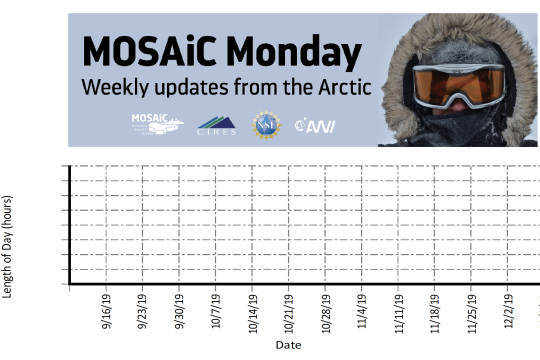
MOSAiC Data Logbook
Your students can be MOSAiC scientists by analyzing real-time data from the expedition each week. Download the MOSAiC Data Log Book and look for the data in each MOSAiC Monday newsletter throughout the expedition. Over time, your students will be able to use the data they've graphed to make interpretations about seasonality in the Arctic and Arctic weather conditions. *Note: We expect data to fall within the following ranges: Length of Day: 0 to 24 hours Temperature: -40 to 14 °C Sea Ice Extent: 3 to 15 million km2 Download the MOSAiC Data Log Book
Project of Mosaic Quick bite
Subject: Analyzing and interpreting data, Earth science, Expeditions
Grade Level: K-2, 3-5, Middle School, High School, University/college
Developer: CIRES
Create Classroom Ice Cores
Students analyze two different ice core models (made of layers of ice frozen in pringles cans) to observe changes in past climates.
Lesson plan
Subject: Analyzing and interpreting data, Climate, Earth science, Engineering and technology, Physical science
Grade Level: Middle School, High School
Developer: Byrd Polar and Climate Research Center
Sea Ice and Heat: A Vicious Cycle
Students explore the different heat absorption of ice and open water using a simple experimental set up.
Lesson plan
Subject: Developing and using models, Earth science, Physical science, Sea ice
Grade Level: Middle School, High School
Developer: UCAR, Center for Science Education
Students explore the different heat absorption of ice and open water using a simple experimental set up.
Lesson plan
Subject: Developing and using models, Earth science, Physical science, Sea ice
Grade Level: Middle School, High School
Developer: UCAR, Center for Science Education
Impacts of a Warming Arctic
Using NASA data, learners evaluate evidence for decreasing ice in the Arctic and explore the impact of global climate change on the Arctic.
Lesson plan
Subject: Analyzing and interpreting data, Atmosphere, Climate, Constructing explanations, Earth science, Sea ice
Grade Level: Middle School, High School, University/college, Adult
Developer: NASA
Arctic Ocean Exploration: Current Events
Using authentic data and two hands on activities, students explore the driving forces for ocean currents, with a focus on the Arctic Ocean.
Lesson plan
Subject: Analyzing and interpreting data, Developing and using models, Earth science, Oceans and ocean circulation, Physical science, Sea ice
Grade Level: High School
Developer: NOAA
One World Ocean
In this hands-on activity, students learn about ocean currents and the difference between salt and fresh water using colored ice cubes and glasses of fresh and salt water.
NGSS Aligned Lesson plan
Subject: Developing and using models, Earth science, Oceans and ocean circulation, Physical science
Grade Level: 3-5, Middle School
Developer: Teach Engineering
The Very, Very Simple Climate Model
Through a simple online model, students learn about the relationship between average global temperature and carbon dioxide emissions while predicting temperature change over the 21st Century.
Lesson plan
Subject: Climate, Developing and using models, Earth science, Obtaining and evaluating information
Grade Level: Middle School, High School
Developer: UCAR, Center for Science Education
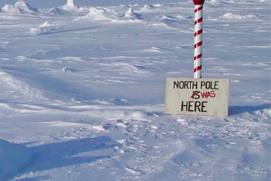
Story Map: How many North Poles does the Earth Have?
In this story map, learners can explore the different north poles (e.g., geographic, magnetic).
Data visualization
Subject: Earth science, Geography
Grade Level: Middle School, High School, University/college, Adult
Developer: ESRI
In this story map, learners can explore the different north poles (e.g., geographic, magnetic).
Data visualization
Subject: Earth science, Geography
Grade Level: Middle School, High School, University/college, Adult
Developer: ESRI
To the Ends of the Earth: Comparing the Arctic and Antarctic
Students sort picture cards using a Venn diagram to find similarities and differences between the Arctic and Antarctic.
NGSS Aligned Lesson plan
Subject: Earth science, Geography
Grade Level: 3-5, Middle School
Developer: U.S. Ice Drilling Program
Students sort picture cards using a Venn diagram to find similarities and differences between the Arctic and Antarctic.
NGSS Aligned Lesson plan
Subject: Earth science, Geography
Grade Level: 3-5, Middle School
Developer: U.S. Ice Drilling Program
Arctic Climate Curriculum: Exploring the Arctic
This activity introduces students to the Arctic, including different definitions of the Arctic and exploration of the Arctic environment and Arctic people. Students set out on a virtual exploration of the geography of the Arctic using Google Earth. Students go on to learn about meteorological parameters that are measured by Arctic research teams and practice the measurements in hands-on activities.
Lesson plan
Subject: Analyzing and interpreting data, Arguing from evidence, Asking questions, Computational thinking, Earth science, Geography, Life science, Obtaining and evaluating information, Physical science, Planning investigations
Grade Level: Middle School, High School, University/college
Developer: CIRES
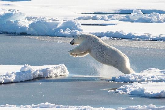
Polar Bears in a Warming World:A Climate Change Lesson
Students will locate and distinguish the four major sea ice eco-regions in the Arctic and explore the impacts of sea ice loss over time due to climate change and the ensuing threats these changes may have on the Arctic ecosystem and its inhabitants.
Lesson plan
Subject: Climate, Constructing explanations, Earth science, Ecosystems, Life science, Sea ice
Grade Level: 3-5, Middle School
Developer: Polar Bears International
EcoChains: Arctic Life Game
The EcoChains Arctic Life game accurately models the effects of climate change on wildlife food-webs. The game shows how human actions such as the development of alternative energy can influence carbon pollution.
Game
Subject: Arguing from evidence, Constructing explanations, Earth science, Ecosystems, Life science, Obtaining and evaluating information, Sea ice
Grade Level: 3-5, Middle School, High School
Developer: Ecochains

Arctic Climate Curriculum: Exploring Arctic Climate Data
Students dig into authentic Arctic climate data to unravel some causes and effects related to the seasonal melting of the snowpack. In particular, students learn about albedo and its relationship to snowmelt. This concept applied to global climate change on a large scale as well, and students go on to learn about the role of albedo as a self-reinforcing feedback mechanism.
NGSS Aligned Lesson plan
Subject: Analyzing and interpreting data, Arguing from evidence, Climate, Computational thinking, Constructing explanations, Earth science, Physical science
Grade Level: Middle School, High School, University/college
Developer: CIRES
Arctic Climate Curriculum: Do you really want to visit the Arctic?
This jigsaw activity is designed for students to become familiar with several datasets of Arctic weather data, collected in Eureka on Ellesmere Island. Students join a role-playing activity to read and interpret graphs while considering the optimal time to plan a research mission to the Arctic.
NGSS Aligned Lesson plan
Subject: Analyzing and interpreting data, Arguing from evidence, Asking questions, Climate, Computational thinking, Constructing explanations, Earth science, Obtaining and evaluating information, Physical science
Grade Level: Middle School, High School, University/college
Developer: CIRES
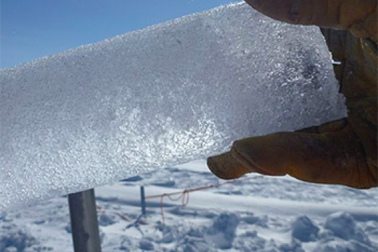
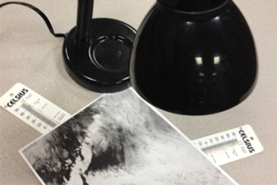
Albedo: measuring the reflective properties of different surfaces
Students measure the albedo and surface temperature of various ice surfaces and changing processes as the ice melts over time. Students apply what they’ve learned in the experiment to the understanding of albedo, and the role albedo plays in the Earth’s energy budget.
NGSS Aligned Lesson plan
Subject: Analyzing and interpreting data, Asking questions, Developing and using models, Earth science, Obtaining and evaluating information, Physical science, Planning investigations, Sea ice
Grade Level: Middle School, High School, University/college
Developer: U.S. Ice Drilling Program