University/college
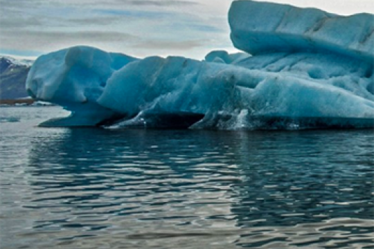
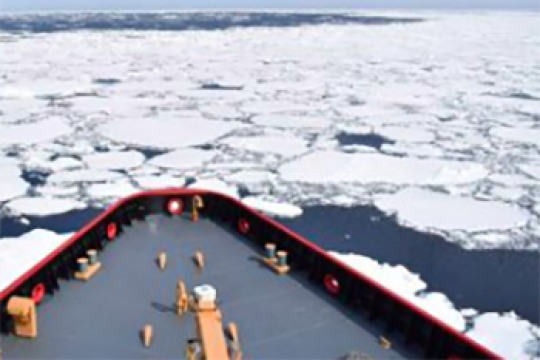
New Ice, New Problems
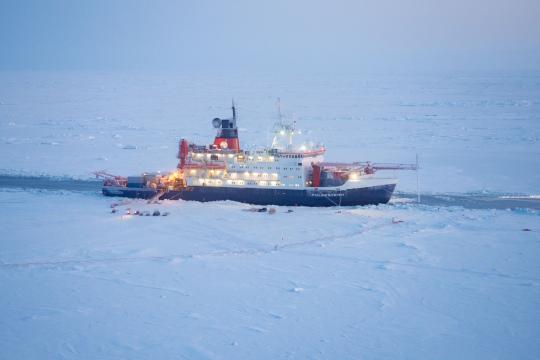
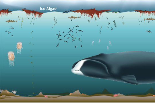
The sea ice in the Arctic is becoming newer and thinner. What kinds of impacts could this have on the Arctic region? Photo credit: Jan Rohde/AWI
Lesson plan
Subject: Expeditions, mosaic monday, Obtaining and evaluating information, Oceans and ocean circulation, Sea ice
Grade Level: Middle School, High School, University/college
Developer: CIRES
Quick Bite: Melting Ice-Albedo Feedback
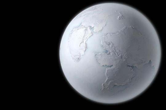
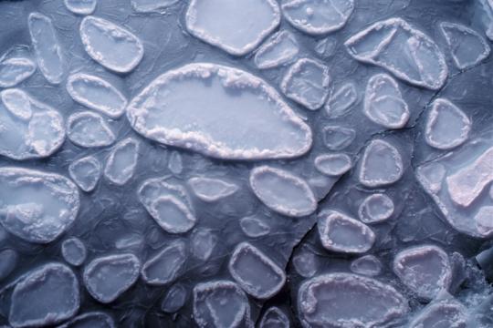
Sea ice extent in the Arctic is on the decline. Could the opposite of a Snowball Earth happen? Figure credit: MIKKEL JUUL JENSEN/SPL/COSMOS
Project of Mosaic Quick bite
Subject: Arguing from evidence, Climate, Earth science, mosaic monday, Sea ice
Grade Level: Middle School, High School, University/college
Developer: CIRES
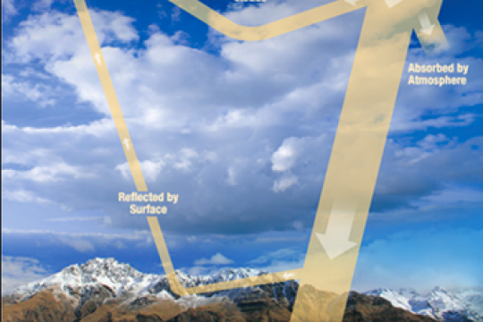
Quick Bite: Budget Your Money, Budget Your Energy
Just like you and I might have a financial budget, Earth has an energy budget. In this Quick Bite activity, students will explore this energy budget and what happens if it changes. Photo credit: Stefan Hendricks/AWI
Project of Mosaic Quick bite
Subject: Atmosphere, Climate, Developing and using models, Earth science, mosaic monday
Grade Level: Middle School, High School, University/college
Developer: CIRES
Quick Bite: Buoy Structure and Function
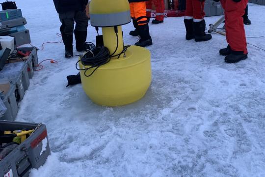
In this Quick Bite activity, your students will read about SIMB buoys, watch a video of a buoy installation during the 2019-2020 MOSAiC expedition, and then discuss the structure and function of a buoy. Photo credit: Anne Gold, CIRES/CU Boulder
Project of Mosaic Quick bite
Subject: Constructing explanations, Engineering and technology, Expeditions, mosaic monday, Oceans and ocean circulation
Grade Level: Middle School, High School, University/college
Developer: CIRES
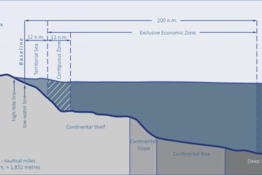
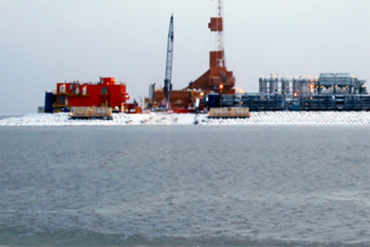
Quick Bite: Planting a Flag in the Arctic: Not so EEZ
To claim underwater territory, coastal nations must first understand their nearshore seafloor geology. In this short activity, your students will examine maps of Arctic Ocean bathymetry and identify continental shelves of the Arctic coastal nations.
Project of Mosaic Quick bite
Subject: Earth science, Geography, Geopolitics, mosaic monday
Grade Level: Middle School, High School, University/college
Developer: CIRES
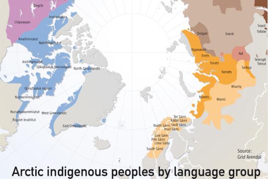
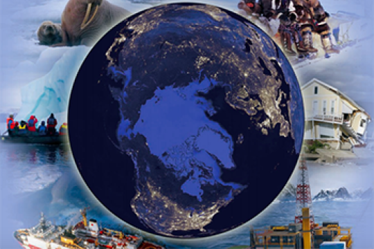
Quick Bite: Who Lives in the Arctic?
About 4 million people live in the Arctic, 10-12% of which are Indigenous peoples with a diversity of cultures and ways of life. In this activity, your students will learn more about who lives in the Arctic using information from maps.
Project of Mosaic Quick bite
Subject: Geography, mosaic monday, Obtaining and evaluating information
Grade Level: Middle School, High School, University/college
Developer: CIRES
Quick Bite: (Re)Defining the Arctic
There are several ways to define the Arctic region geographically. In this Quick Bite activity, students will explore how a changing climate could change these geographic definitions.
Project of Mosaic Quick bite
Subject: Climate, Constructing explanations, Earth science, Geography, mosaic monday
Grade Level: Middle School, High School, University/college
Developer: CIRES
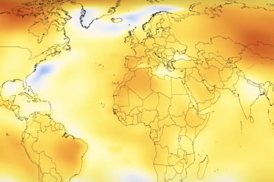
Quick Bite: You're Getting Warmer...
Looking at how global temperatures have changed over time can give us valuable insight into our planet's health. In this Quick Bite activity, students watch an animation of global temperature anomalies over time to discover that something strange is going on in the Arctic.
Project of Mosaic Quick bite
Subject: Analyzing and interpreting data, Climate, Earth science, Geography, mosaic monday
Grade Level: Middle School, High School, University/college
Developer: CIRES
MOSAiC Math
Can you solve these MOSAiC expedition math problems?
Project of Mosaic Quick bite
Subject: Computational thinking, Expeditions, mosaic monday
Grade Level: Middle School, High School, University/college
Developer: CIRES
Can you solve these MOSAiC expedition math problems?
Project of Mosaic Quick bite
Subject: Computational thinking, Expeditions, mosaic monday
Grade Level: Middle School, High School, University/college
Developer: CIRES
Explore the Arctic virtually Aboard the Fram
Project of Mosaic Lesson plan
Subject: Engineering and technology, Expeditions, Geography, mosaic monday
Grade Level: Middle School, High School, University/college
Developer: CIRES
Project of Mosaic Lesson plan
Subject: Engineering and technology, Expeditions, Geography, mosaic monday
Grade Level: Middle School, High School, University/college
Developer: CIRES
Know Your Ocean: Polar Research
Learn more about polar topics like glaciers and ice sheets, Arctic sea life, and sea ice in these polar research educational modules from the Woods Hole Oceanographic Institution.
Subject: Earth science, Ecosystems, Geography, Life science, Obtaining and evaluating information, Oceans and ocean circulation, Physical science, Sea ice
Grade Level: Middle School, High School, University/college, Adult
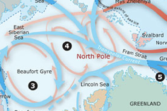
Polar Discovery: Arctic Ocean Circulation
The Arctic Ocean is a unique part of the globe, covered by ice much of the year and fairly isolated from the other oceans. Learn about how water in the Arctic Ocean moves around and why using this interactive graphic from the Woods Hole Oceanographic Institution.
Data visualization
Subject: Earth science, Geography, Obtaining and evaluating information, Oceans and ocean circulation, Physical science
Grade Level: Middle School, High School, University/college, Adult
Polar Discovery: Arctic Ocean Ecosystem
Learn about the various plants and animals that make up Arctic Ocean ecosystems using this interactive graphic from the Woods Hole Oceanographic Institution.
Data visualization
Subject: Ecosystems, Life science, Obtaining and evaluating information
Grade Level: Middle School, High School, University/college, Adult
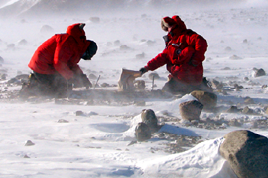
Timing an Arctic Expedition
The MOSAiC (Multidisciplinary Drifting Observatory for the Study of Arctic Climate) expedition officially launched on September 20, 2019 when the icebreaker Polarstern set sail from Tromsø, Norway. The Polarstern will be looking for an ice floe that it can freeze into and drift along with across the Arctic for a year. The ice must be thick enough throughout the year to support the scientists and instruments that will be on it, but close to thinner ice that is easy to drill through. Why did the MOSAiC expedition begin in September? It turns out this isn't random, but a strategically chosen departure date. Challenge your students to use the National Snow and Ice Data Center's Charctic Interactive Sea Ice Graph to come up with an answer to this question. Then, read more about this question here. Photo: M. Van Woert, NOAA
Project of Mosaic Quick bite
Subject: Constructing explanations, Earth science, Expeditions, mosaic monday, Oceans and ocean circulation, Sea ice
Grade Level: Middle School, High School, University/college, Adult
Developer: CIRES

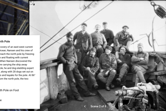
Route of the Fram Expedition (1893-1896)
On July 5th, 1893, the Fram set sail from Tromsø, Norway to try to reach the highest latitude ever attained. Fridtjof Nansen, leader of the Fram expedition, attempted to freeze a custom-built wooden ship in sea ice and use Arctic currents to drift north. See where the Fram--and Nansen--drifted and dogsledded during their three years in the Arctic.
Project of Mosaic Data visualization
Subject: Expeditions, Geography, Oceans and ocean circulation
Grade Level: K-2, 3-5, Middle School, High School, University/college
Fluid Earth Viewer
Explore atmospheric and oceanographic conditions in the Arctic or anywhere else on the globe with this incredible data visualization tool.
Data visualization
Subject: Analyzing and interpreting data, Atmosphere, Earth science, Geography, Oceans and ocean circulation
Grade Level: 3-5, Middle School, High School, University/college, Adult
Developer: Byrd Polar and Climate Research Center
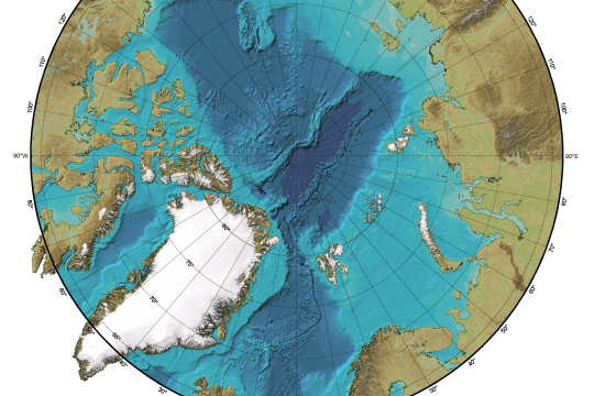
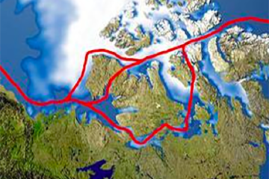
Where is the Arctic?
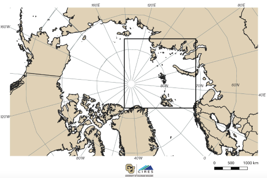
Have your students label and color the countries around the Arctic and do some research about the various people who live in the Arctic region. How is the 'Arctic' defined geographically? Note: We suggest using the this map in conjunction with the "Tracking the Polarstern" map (download both maps and copy them front to back for your students). The inset box on the "Where is the Arctic?" map shows the boundaries for the "Tracking the Polarstern" map.
Project of Mosaic Quick bite
Subject: Geography
Grade Level: K-2, 3-5, Middle School, High School, University/college
Developer: CIRES
MOSAiC Data Logbook
Your students can be MOSAiC scientists by analyzing real-time data from the expedition each week. Download the MOSAiC Data Log Book and look for the data in each MOSAiC Monday newsletter throughout the expedition. Over time, your students will be able to use the data they've graphed to make interpretations about seasonality in the Arctic and Arctic weather conditions. *Note: We expect data to fall within the following ranges: Length of Day: 0 to 24 hours Temperature: -40 to 14 °C Sea Ice Extent: 3 to 15 million km2 Download the MOSAiC Data Log Book
Project of Mosaic Quick bite
Subject: Analyzing and interpreting data, Earth science, Expeditions
Grade Level: K-2, 3-5, Middle School, High School, University/college
Developer: CIRES
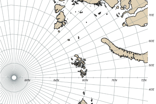
Tracking the Polarstern
The route that the Polarstern will take across the Central Arctic is not fully known. Since the ship will be frozen in the Arctic sea ice and drifting along with it wherever it goes, we can only make predictions about the path will follow. Each week we will provide you with the latitude and longitude coordinates of the Polarstern so that your students can track its journey across the Arctic in your classroom. Download this map and plot your first set of coordinates!
Project of Mosaic Quick bite
Subject: Expeditions, Geography
Grade Level: K-2, 3-5, Middle School, High School, University/college
Developer: CIRES
Sea Ice Predictive Model
Using sea ice extent and carbon dioxide data, students make predictions about future sea ice extent using simple statistics to evaluate a linear relationship. Students compare Arctic and Antarctic conditions.
Lesson plan
Subject: Analyzing and interpreting data, Climate, Computational thinking, Sea ice
Grade Level: High School, University/college
Developer: Joceline Boucher, SERC
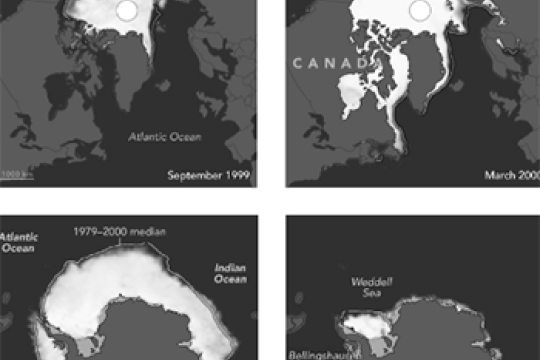
Impacts of a Warming Arctic
Using NASA data, learners evaluate evidence for decreasing ice in the Arctic and explore the impact of global climate change on the Arctic.
Lesson plan
Subject: Analyzing and interpreting data, Atmosphere, Climate, Constructing explanations, Earth science, Sea ice
Grade Level: Middle School, High School, University/college, Adult
Developer: NASA
To Drill or Not to Drill? A Case Study in the Arctic National Wildlife Refuge
In a participatory problem-based activity students evaluate the impacts and benefits of drilling in the Arctic National Wildlife Refuge. Using primary sources, students learn more about the tundra ecosystem and the Arctic, conservation biology, economic and political issues surrounding ANWR, and social perspectives on drilling in a pristine environment.
Lesson plan
Subject: Ecosystems, ELA, Geopolitics, Life science, Obtaining and evaluating information
Grade Level: High School, University/college
Developer: Cassandra Runyon et al., SERC
Arctic SMARTIC (Strategic Management of Resources in Times of Change)
Students will build off of an introductory presentation on climate change in the Arctic to devise a strategy to manage climate change impacts on a global scale (the Arctic). After a brief synopsis on current issues and management approaches in the Arctic, students will use information based on the stakeholders and interests they've identified in readings done before class, to pinpoint areas of high interest, negotiate conflicts, and develop a sustainable, multi-stakeholder management plan for high priority areas.
Lesson plan
Subject: Arguing from evidence, ELA, Geography, Obtaining and evaluating information
Grade Level: High School, University/college
Northwest Passage
Students use Google Earth to explore changing ice conditions in the Arctic, and how these changing conditions affect shipping routes, fossil fuel extraction, geopolitics, and other Arctic issues.
Lesson plan
Subject: Analyzing and interpreting data, Climate, Geography, Geopolitics, Sea ice
Grade Level: High School, University/college
Developer: Glenn Richard, SERC
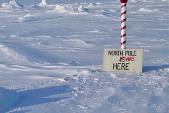
Story Map: How many North Poles does the Earth Have?
In this story map, learners can explore the different north poles (e.g., geographic, magnetic).
Data visualization
Subject: Earth science, Geography
Grade Level: Middle School, High School, University/college, Adult
Developer: ESRI
In this story map, learners can explore the different north poles (e.g., geographic, magnetic).
Data visualization
Subject: Earth science, Geography
Grade Level: Middle School, High School, University/college, Adult
Developer: ESRI
Arctic Climate Curriculum: Exploring the Arctic
This activity introduces students to the Arctic, including different definitions of the Arctic and exploration of the Arctic environment and Arctic people. Students set out on a virtual exploration of the geography of the Arctic using Google Earth. Students go on to learn about meteorological parameters that are measured by Arctic research teams and practice the measurements in hands-on activities.
Lesson plan
Subject: Analyzing and interpreting data, Arguing from evidence, Asking questions, Computational thinking, Earth science, Geography, Life science, Obtaining and evaluating information, Physical science, Planning investigations
Grade Level: Middle School, High School, University/college
Developer: CIRES

Arctic Climate Curriculum: Exploring Arctic Climate Data
Students dig into authentic Arctic climate data to unravel some causes and effects related to the seasonal melting of the snowpack. In particular, students learn about albedo and its relationship to snowmelt. This concept applied to global climate change on a large scale as well, and students go on to learn about the role of albedo as a self-reinforcing feedback mechanism.
NGSS Aligned Lesson plan
Subject: Analyzing and interpreting data, Arguing from evidence, Climate, Computational thinking, Constructing explanations, Earth science, Physical science
Grade Level: Middle School, High School, University/college
Developer: CIRES
Arctic Climate Curriculum: Do you really want to visit the Arctic?
This jigsaw activity is designed for students to become familiar with several datasets of Arctic weather data, collected in Eureka on Ellesmere Island. Students join a role-playing activity to read and interpret graphs while considering the optimal time to plan a research mission to the Arctic.
NGSS Aligned Lesson plan
Subject: Analyzing and interpreting data, Arguing from evidence, Asking questions, Climate, Computational thinking, Constructing explanations, Earth science, Obtaining and evaluating information, Physical science
Grade Level: Middle School, High School, University/college
Developer: CIRES
Albedo: measuring the reflective properties of different surfaces
Students measure the albedo and surface temperature of various ice surfaces and changing processes as the ice melts over time. Students apply what they’ve learned in the experiment to the understanding of albedo, and the role albedo plays in the Earth’s energy budget.
NGSS Aligned Lesson plan
Subject: Analyzing and interpreting data, Asking questions, Developing and using models, Earth science, Obtaining and evaluating information, Physical science, Planning investigations, Sea ice
Grade Level: Middle School, High School, University/college
Developer: U.S. Ice Drilling Program